
Do you love exploring caves and caverns? Do you love hiking interesting trails that don’t involve lots of elevation gain?
If you answered yes to these questions, the Blue Ridge Tunnel (a.k.a. the Crozet Tunnel) offers a one-of-a-kind experience!
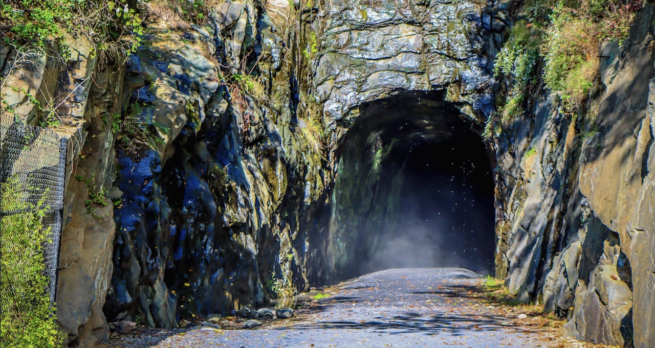
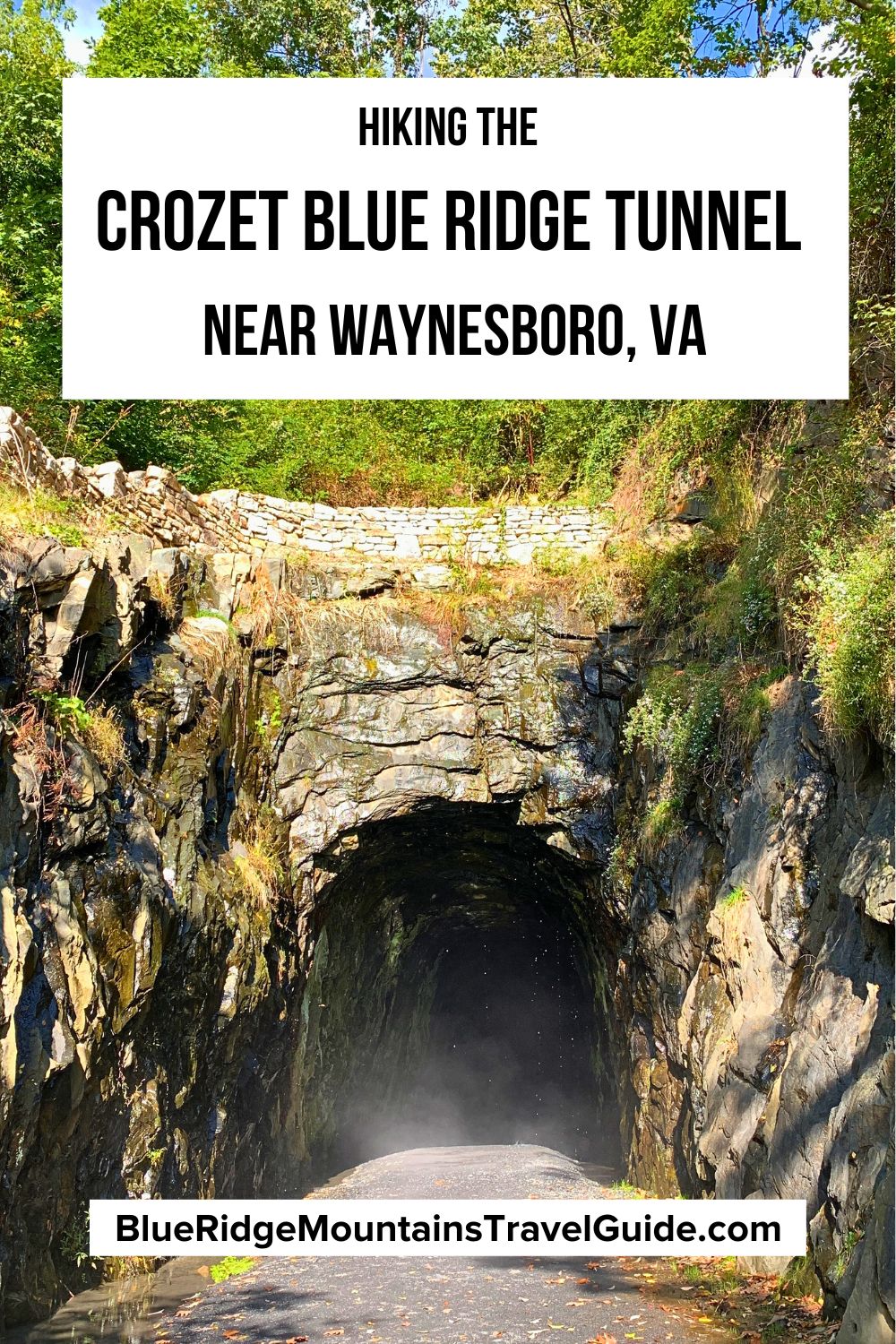
With two entrances (one near Waynesboro VA, the other in Crozet VA), the Blue Ridge Tunnel hike offers a temperature-controlled stroll through a cave-like tunnel complete with little brown bats and salamanders.
Also known as the Crozet Tunnel or Claudius Crozet Blue Ridge Tunnel, this historic site is located between two of our favorite breweries, the Basic City Beer Co. in Waynesboro and Pro Re Nata in Crozet.
For us, the Blue Ridge Tunnel trail is a great way to burn off some calories before or after visiting two of our favorite Virginia mountain towns!
Popular with hikers of all ages and abilities, the tunnel is also a favorite for bikers and joggers. When the weather is nice, you’ll see plenty of people enjoying the pet-friendly trail, including young families (it’s stroller friendly).
Read on for our guide to hiking the Claudius Crozet Blue Ridge Tunnel Trail, including some fascinating history of the tunnel and all the info you need to follow the rail trail through Scott Mountain.
READ MORE: The 10 Best Caves and Caverns in Virginia

Blue Ridge Tunnel Trail Info
ADDRESS: West Trailhead- 483 Three Notched Mountain Hwy, Waynesboro VA; East Trailhead- 215 Afton Depot Lane, Afton VA
PHONE: 434-263-7015
COST OF ENTRY: Free
HOURS: Open from dawn to dusk all year-round
PARKING: Free parking is available at both the east and west Crozet Tunnel trailheads.
Directions From Waynesboro VA
To reach the Blue Ridge Tunnel trail west trailhead from Waynesboro, follow West Main St to US-250 East for 1.2 miles. Turn right onto Three Notched Mountain Hwy and you’ll reach the west trailhead parking lot in about a 1/2-mile.
For the Blue Ridge Tunnel trail east trailhead, follow West Main St to US-250 East for 3.2 miles. Turn right onto VA-6 East for 0.5 miles, then turn right onto Afton Depot Lane to access the east trailhead parking lot.
READ MORE: The 10 Best Things to Do in Waynesboro VA (Augusta County)
Blue Ridge Tunnel History
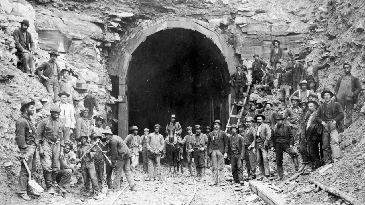
The Blue Ridge Tunnel (a.k.a. the Claudius Crozet Blue Ridge Tunnel) is a historic train tunnel that was built in the 1850s, several years before the start of the Civil War.
This 4,237-foot-long tunnel was the westernmost of four tunnels designed by French engineer Claudius Crozet to cross the Blue Ridge Mountains at Rockfish Gap in central Virginia.
It was a massive undertaking, especially when you consider that the work was done mostly by hand (primarily by Scots-Irish laborers and enslaved African Americans), using drills, pickaxes, and black powder.
Upon the completion of construction in 1858, the railroad tunnel was the longest of its kind in the USA, opening up the Shenandoah Valley of Virginia to the Blue Ridge Railroad.
In 1944, the Chesapeake & Ohio Railway replaced the Blue Ridge Tunnel with a new tunnel designed to accommodate the larger modern locomotives. This train tunnel is still in use today.
More recently, the original Crozet Tunnel was restored over a span of 20 years to be a multi-use hiking trail, thanks to the efforts of Nelson County VA and the Blue Ridge Tunnel Foundation.
Opened to the public in November 2020, this unique crushed stone hiking trail is now enjoyed by outdoor enthusiasts, history buffs, and railroad fans alike.
READ MORE: The 10 Best Civil War Battlefields in Virginia to Visit
Hiking the Crozet Blue Ridge Tunnel Trail
The Blue Ridge Tunnel Trail has two access points. Its western trailhead is located near the Blue Ridge Mountain town of Waynesboro VA, while the eastern trailhead is near one of our favorite towns, Crozet VA.
Located at 483 Three Notched Mountain Highway, the parking lot for the western trailhead features 20 parking spaces.
This end of the trail has a steeper grade, so visitors with limited mobility will want to use the eastern trailhead instead.
We prefer to take the east trailhead, which is located at 215 Afton Depot Lane. It’s mostly flat and fully accessible from this side, with 50+ parking spaces and views of the active railroad line.
As you’re walking to the Crozet Tunnel, you may see one of our favorite things to so in the Shenandoah Valley, the Shenandoah Valley Limited, an exciting train ride that travels through the new tunnel.
Note that this easy trail is about 2.25 miles each way, and it takes an average of 1 hour and 42 minutes for people to complete the 4.6-mile round-trip trek.
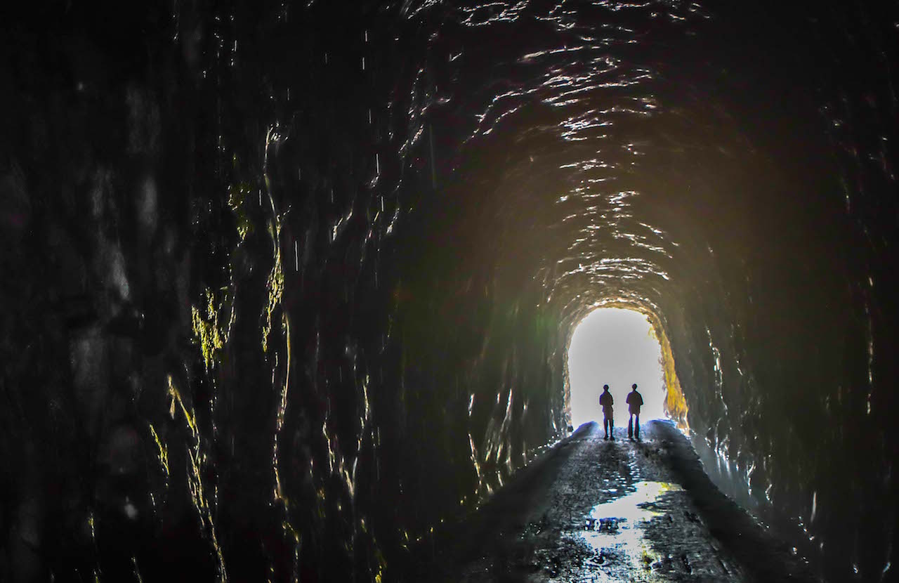
Hiking the tunnel feels like you’re in a cave, with year-round temperatures of 50ºF. In our experience, this makes for a refreshing cool hike in Summer, or an escape from the cold during Winter in Virginia.
READ MORE: The 10 Best Things to Do in the Shenandoah Valley of Virginia
What To Bring to Hike the Blue Ridge Tunnel
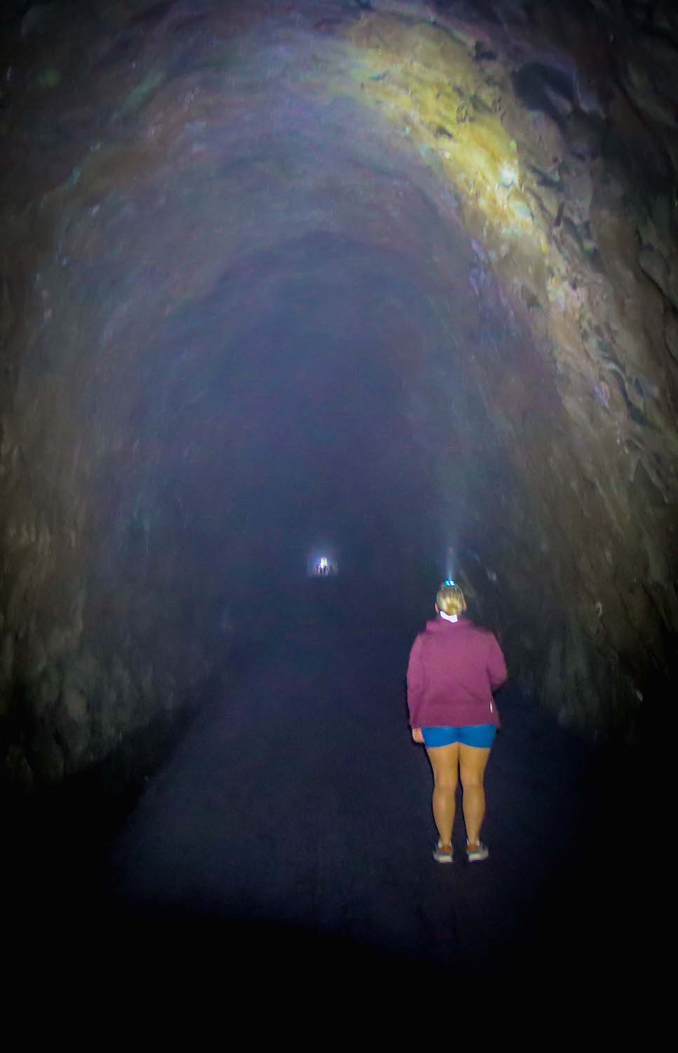
Note that the tunnel is damp all year-round, with puddles and loose stones.
We recommend wearing sturdy waterproof hiking shoes, and layers of clothing for 50ºF temperatures.
Water drips from the top and sides of the tunnel constantly, so a waterproof jacket would also come in handy.
Blue Ridge Tunnel Trail maps are available online for download, or you can find them at either of the two trailheads.
The tunnel is very dark, and at times you won’t be able to see the light at either end. We highly recommend wearing a high-powered headlamp and/or bring a flashlight so you don’t miss any of the interior magic of this special place!
I always bring my camera to capture photos of the tunnel, local wildlife (and wildflowers), and the stunning fall foliage.
It’s also a good idea to pack water, snacks, and any other basic hiking essentials you may need.
READ MORE: The 40 Best Camping Gifts & Hiking Gifts

FAQs
How long does it take to walk through the Blue Ridge Tunnel?
Though it’s considered a relatively easy route, the trail is 4.6 miles round-trip, and the average time needed to complete it is just under two hours.
The trail surface is gravel, and width varies from 8 feet to wider in most areas. This trail allows dogs on-leash only.
How deep is the Blue Ridge Tunnel?
The tunnel is located 720 feet below the surface of Scott Mountain in Nelson County VA.
Are there bats in the Blue Ridge Tunnel?
In addition to fellow hikers, we have seen occasional Brown Bats and Salamanders inside the tunnel.
How hot/cold is the Blue Ridge Tunnel Trail?
The temperature is approximately 50ºF, making this literally the “coolest hike in Virginia.”
Where do you park for the Blue Ridge Tunnel trail?
With its easier access, the east trail is recommended for those using wheelchairs, mobility equipment, or strollers. The east trail is also regarded as a less strenuous experience.
Note that portable restrooms can be found at both the east and west parking lots, but not along the trail. –by Heather Taylor & Jon Weaver; all photos by Bret Love & Mary Gabbett unless otherwise noted

