
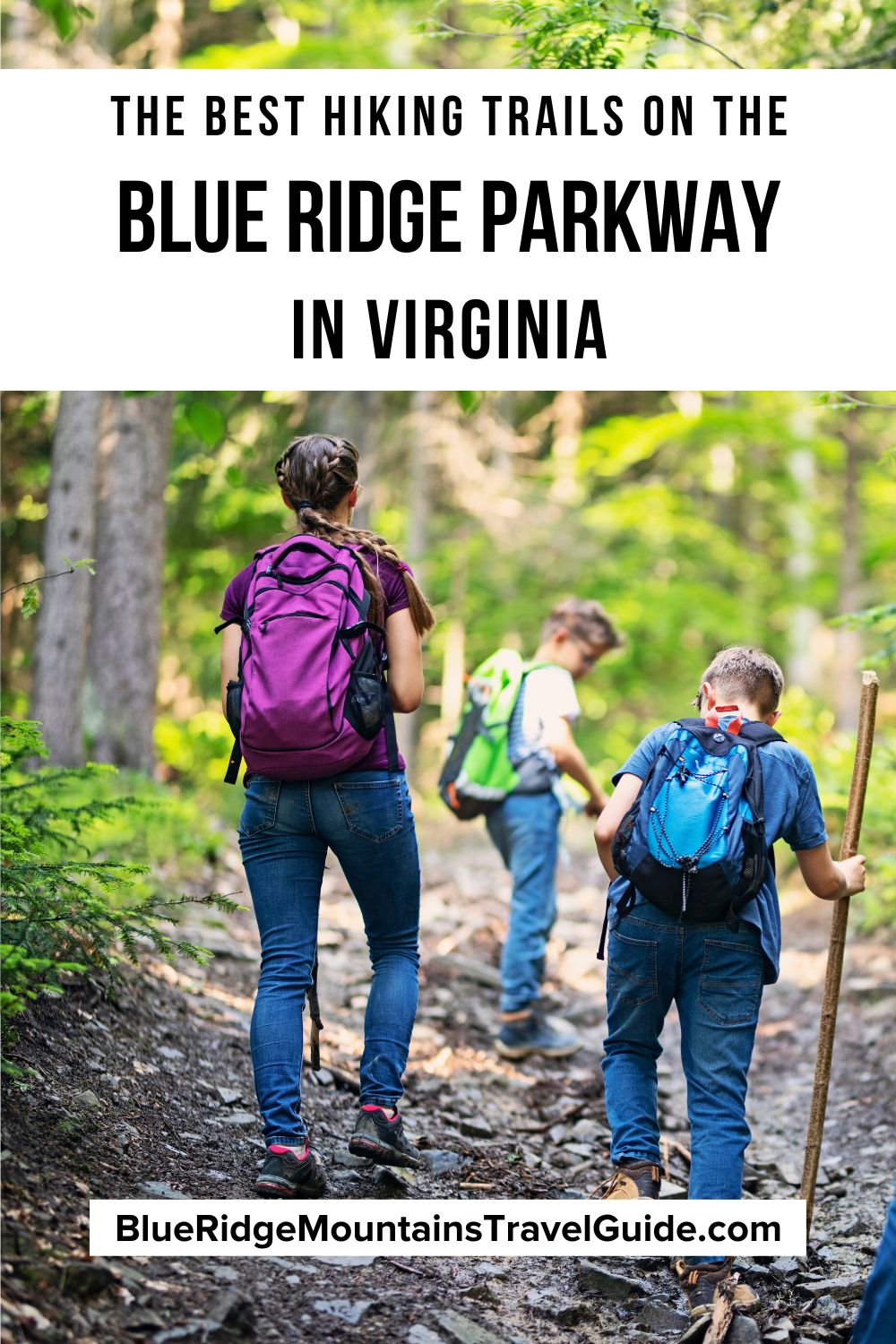
Spanning 469 miles in North Carolina and Virginia, the Blue Ridge Parkway should be on the bucket list of any avid hiker or road trip enthusiast.
With more than 200 overlooks along the ever-popular scenic route, you don’t have to get out of the car to savor stunning scenic views of the Blue Ridge Mountains.
If you are up for trekking adventures, there are some exceptionally rewarding hikes along the Blue Ridge Parkway in Virginia.
This world-renowned road trip starts in the heart of the Shenandoah Valley in Waynesboro VA, where Skyline Drive (which runs through Shenandoah National Park) ends.
The Blue Ridge Parkway in VA runs through the George Washington and Jefferson National Forests, then heads into pastoral stretches of meadows and farms.
From family-friendly strolls around beautiful lakes to near-vertical clambers up sheer mountains, hiking Virginia’s portion of the BRP could keep you very busy indeed!
Read on for our guide to some of the best hiking trails on the BRP in Virginia, including hikes that include mills, waterfalls, historic peaks, canal locks, and lakes!
READ MORE: The 15 Best Blue Ridge Parkway Hotels & Cabin Rentals in NC & VA
Hiking Trails on the Blue Ridge Parkway in Virginia
- Humpback Rocks
- Otter Creek/Otter Lake
- James River Canal Locks
- Apple Orchard Falls
- Fallingwater Cascades
- Flat Top Mountain
- Abbott Lake Loop at Peaks of Otter Lodge
- Johnson Farm Loop
- Sharp Top Mountain
- Mabry Mill
READ MORE: A Detailed History of the Blue Ridge Parkway

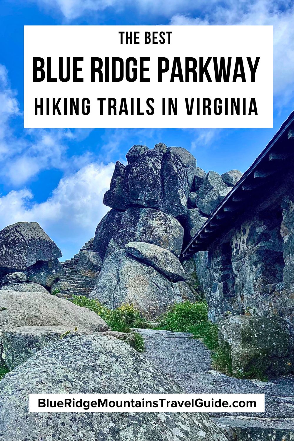
1. Humpback Rocks (Milepost 5.8)
Near the northernmost point on the Blue Ridge Parkway, overlooking the Shenandoah Valley, Humpback Rocks served as a landmark for wagons traveling over the Howardsville Turnpike in the 1840s.
Nowadays, this area is a hotspot for some exciting hiking trails and jaw-dropping vistas.
Some of the most popular hiking trails here include the easy 0.25-mile Mountain Farm Trail, a strenuous 2-mile section of the Appalachian Trail in VA, the moderate 0.3-mile Catoctin Loop Trail, and the moderate 0.2-mile Greenstone Trail.
From the Humpback Gap parking lot, it’s 1 mile to Humpback Rocks and a 2-mile hike to Humpback Mountain. The climb to Humpback Rocks is strenuous, but the jaw-dropping views are a sensational reward. The trail beyond the summit leads to the Humpback Rocks picnic area.
In addition to hiking trails, this area of the BRP has a Visitor Center with a museum and gift shop where you can pick up a map and souvenirs.
There’s also an outdoor Historic Farm Museum, where you can wander around late 19th century buildings and get a taste of life in the Blue Ridge Mountains of Virginia in the 1800s!
READ MORE: Hiking the Crozet Blue Ridge Tunnel Trail Near Waynesboro VA
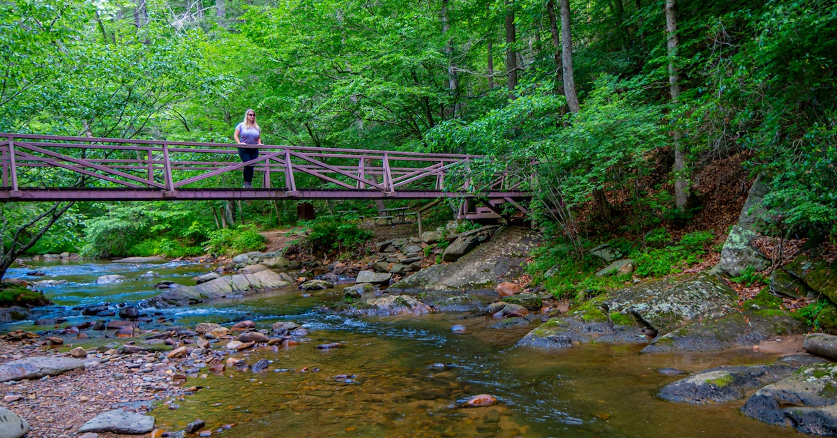
2. Otter Creek/Otter Lake (MP 64)
Part of the Otter Creek Recreation Area and George Washington National Forest, this fairly easy 7.5-mile trail winds its way along Otter Creek.
Start your hike on the Otter Creek Trail at the James River Visitor Center (MP 64). About 0.9 miles in, you’ll intersect with the Otter Lake Loop Trail. This trail will have you crossing creeks, and even the Blue Ridge Parkway.
At 3.7 miles, you’ll reach the Otter Creek Campground Restaurant, which makes for a fine reward before backtracking to the Visitor Center. The campgrounds has 45 tent sites and 24 RV hookups.
Hikers can veer off and take the 0.9-mile Otter Lake Loop Trail to enjoy beautiful views of the lake. Look out for evidence of beaver activity and other Virginia wildlife.
Near the Visitor Center, you can enjoy the 0.4-mile Trail of Trees loop, where signs help you to identify the many types of trees surrounding you. You’ll also get to see a stunning view of the James River!
The Otter Creek Trail can also be accessed from VA Blue Ridge Parkway Overlooks at MP 61.4, 62.5 and 63.1.
READ MORE: The 20 Best Blue Ridge Parkway Restaurants in VA & NC

3. James River Canal Locks (MP 63.7)
If you visit the James River Visitor Center and/or Otter Creek Trail, don’t miss the James River Canal Trail!
This 0.4-mile loop trail takes you along the remnants of the Kanawha Canal. The trail itself is easy, but note that there are steps to contend with at each end of the hike.
This canal was proposed by George Washington, and was originally intended to join the Atlantic Ocean with the Ohio River Valley by way of the James and Kanawha Rivers.
The Canal Trail starts at the Visitor Center. You’ll cross a bridge before descending 39 steps to the riverside, then follow the original path downstream to Battery Creek Lock and its weir.
There you’ll find exhibits relating to the history and engineering of the lock. From this point, you can also look upstream and see the James River Water Gap, where the river passes through the mountains.
This canal served as a major transportation route connecting the Atlantic Ocean with inland Virginia in the 1800s, and operated from 1821 to 1877.
READ MORE: Camping and Hiking in Natural Bridge State Park, VA
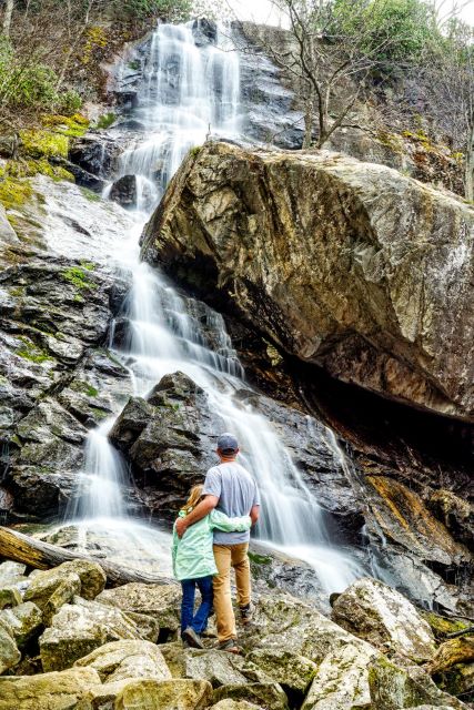
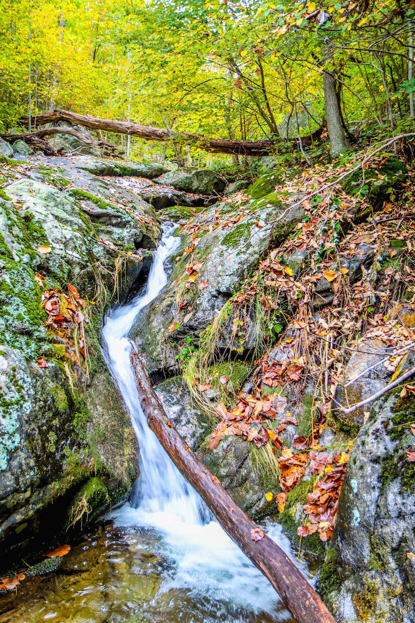
4. Apple Orchard Falls (MP 78)
In my opinion any hike with a waterfall at the end is always a bonus, and this Virginia waterfall hike will not disappoint! Starting at Sunset Fields on the BRP, follow the Apple Orchard Falls Trail.
If you only want to hike to the waterfall and back, this is just a 2.9-mile round-trip trail.
Follow the North Creek down Apple Orchard Mountain until you reach the platform that overlooks this 200-foot waterfall, then take the boardwalk to the base. Be sure to leave plenty of time to take a refreshing dip in the creek!
If you choose to hike to the top of Apple Orchard Mountain, you’ll find a spot where the Appalachian Trail (AT) passes by. For those hiking the AT, there’s the Cornelius Creek Shelter near the summit.
The top of the mountain is also home to a Naval radar station (which is not open to the public), which adds a peculiar human-made landmark to the otherwise pristine natural vista.
Note that you won’t actually be picking apples along the trail. The mountain gets its name from gnarly red oaks that have been stunted by harsh weather, so they look like the heavily pruned trees in an apple orchard.
READ MORE: The 10 Best Waterfalls on/near the Blue Ridge Parkway in Virginia
5. Fallingwater Cascades (MP 83)
The Fallingwater Cascades Trail is a 1.6-mile loop trail that can be accessed from either the Fallingwater Cascades Parking Area or the Flat Top Trail Parking Area, which just a half-mile further away.
This moderate to strenuous trail starts with a downhill hike to Fallingwater Creek. Note that you will have to climb back uphill on your way out!
The trail mostly follows along the creek, where you’ll have pretty views of water crashing over boulders and rocks. You’ll also be treated to views of Flat Top and Sharp Top Mountains.
You’ll reach the upper falls in around 2000 feet, but it’s well worth making the whole loop rather than backtracking. In another half-mile, you can see water cascading down the 100-foot waterfall.
This trail isn’t as populated as some of the other Blue Ridge Parkway waterfalls, so it’s a good hike for those who like a bit of peace and solitude.
This trail is part of the longer Fallingwater-Flat Top National Recreation Trail. After you’ve hiked the loop, hardy trekkers can cross over the Blue Ridge Parkway to pick up the trail to ascend Flat Top Mountain.
READ MORE: How to Plan an Amazing Blue Ridge Parkway Road Trip
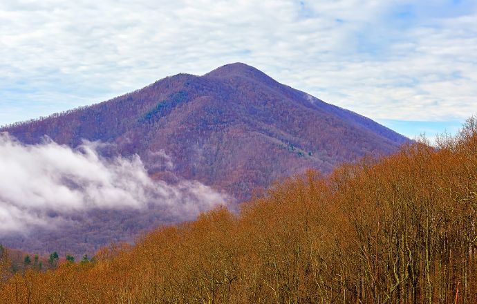
6. Flat Top Mountain (MP 83/86)
Flat Top Mountain is one of the three Peaks of Otter, and there are two ways to access it. You can start a 4.7-mile out-and-back hike near Abbot Lake, or take a 5.7-mile out-and-back hike from the parking lot at Milepost 83.
This is considered a difficult hike, with a steep uphill and a rocky trail that can be quite uneven in places. Flat Top is the tallest of the Peaks of Otter at 4,004 feet in elevation!
The trail is well signposted, and there are plenty of rock outcroppings, benches, and other places to sit to soak in scenic views, rest, and have a snack.
When you see a sign labeled “Cross Rock,” keep your eyes peeled for an interesting geological formation wherein rocks appear to have been stacked in the form of a cross.
You’ll also spot stunning views of Harkening Hill (another Peak of Otter) and the Johnson Farm. From the summit, you can see the Piedmont Valley to the east and Sharp Top Mountain (the third Peak of Otter) to the south.
READ MORE: The 20 Best Overlooks on the Blue Ridge Parkway in Fall
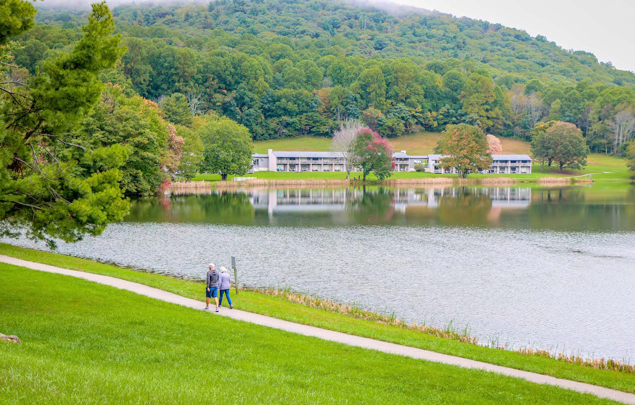
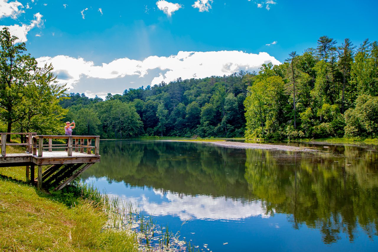
7. Abbott Lake Loop at Peaks of Otter Lodge (MP 85.6)
The easy 1-mile Abbot Lake Trail wraps around a 24-acre lake, offering a lovely waterside experience.
Start your hike at the Peaks of Otter Lodge, which has rooms overlooking the Virginia mountain lake. From the parking lot, follow the trail near a tunnel under the Blue Ridge Parkway and continue on the walkway around the lake.
This paved and gravel trail is ideal for families with young children, strollers, wheelchair users, dogs, and those unable to deal with the roots and rocks of less accessible trails.
There are lots of spots along the trail where you can take in the views, enjoy a prepared picnic, or just rest a bit. There’s also an area with a fire pit, chairs, and cornhole boards for fun gatherings.
Sections of this trail offer the opportunity to walk through woodland and meadow, making for a great chance to see Virginia wildflowers and local wildlife.
On the back side of the lake, you can check out Polly Wood’s Ordinary, a log cabin that was used as an inn from 1832 to the 1850s. You can see it from the trail, but it’s not wheelchair accessible (as you need to go off-trail to visit it).
READ MORE: The 10 Best Things to Do in Bedford VA
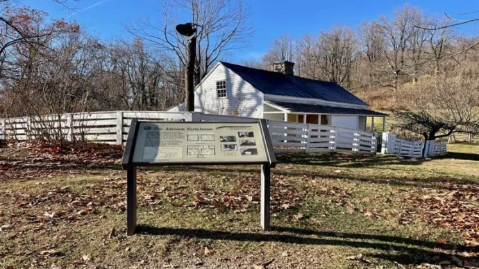
8. Johnson Farm Loop (MP 85.6)
The Johnson Farm Trail is a 2.1-mile loop that guides visitors around the Historic Johnson Farm. You can find the trailhead at the Peaks of Otter Visitor Center, or from the Peaks of Otter Lodge.
Built in 1854, the farm was occupied by three generations of the family, who lived there until the early 1940s. It was restored to become the outdoor history museum that we see now in the 1970s.
Comprised mostly of dirt and gravel, the hiking trail is considered easy to moderate in difficulty, and makes for a great family- and pet-friendly outing. Hike the loop in a counterclockwise direction for less of an uphill climb.
There are often living history demonstrations by costumed staff, who can give you a better idea of life on a 19th century farm. They happen during operating hours, but the buildings can be viewed from the outside anytime.
Visitors can see the old Johnson family farmhouse, a springhouse, and various antique farming equipment that is on display around the campus.
READ MORE: The 13 Best Blue Ridge Parkway Campgrounds to Visit

9. Sharp Top Mountain (MP 92)
One of the three Peaks of Otter, Sharp Top Mountain reaches 3,875 feet in elevation. Though it’s just a 3-mile hike to the summit and back, this one is NOT for the faint-hearted.
The steep hike up to the summit of Sharp Top Mountains ascends some 1300 feet, but hikers will be rewarded with breathtaking 360º views of the other Peaks of Otter.
In addition to stunning overviews of Abbot tLake and the Peaks of Otter Lodge, hikers will also pass an abandoned stone building that was home to a convenience store in the 1950s and 60s.
This trail is not only steep, but also rocky and uneven in places, and there are some steps to climb. That being said, it’s one of the most popular hiking trails on VA’s Blue Ridge Parkway for good reason.
Since this is such a popular hike, arrive early to ensure a parking spot at the Peaks of Otter Visitor Center. There’s also additional parking at the Peaks of Otter Recreation Area and the Peaks of Otter Lodge parking lot.
The nearby Peaks of Otter Campground is a great place to camp, with a view of Sharp Top Mountain!
READ MORE: The 10 Best Campgrounds in Virginia
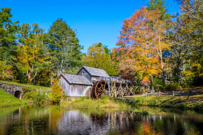
10. Mabry Mill (MP 176)
One of the most photographed places on the Blue Ridge Parkway, the historic Mabry Mill attracts hundreds of thousands of visitors every year.
Edwin Mabry started building this picturesque grist mill and adjoining farm buildings in 1903. He and his wife, Lizzie, worked here for three decades, grinding corn for the local community.
Water was supplied by two creeks, which made for a slower turn of the wheel but created a super-fine cornmeal that their customers loved.
The grist mill and sawmill have been restored so that visitors can experience live exhibits of the milling processes. Buildings such as the woodworking shop and blacksmith shop often feature staff offering living history demonstrations.
You may also get a chance to see old-time skills such as basket weaving, seat caning, spinning, and weaving.
Park at the Mabry Mill Restaurant/Gift Shop and walk the easy 0.5-mile trail to the farm buildings. The gift shop sells local products, crafts, and the usual National Park Service souvenirs. –by Emma Gallagher; featured image of the Otter Creek Overlook by Bret Love & Mary Gabbett
