
[Updated August 12, 2021]
If you’re looking for challenging North Carolina waterfalls to hike, Hooker Falls is probably not for you.
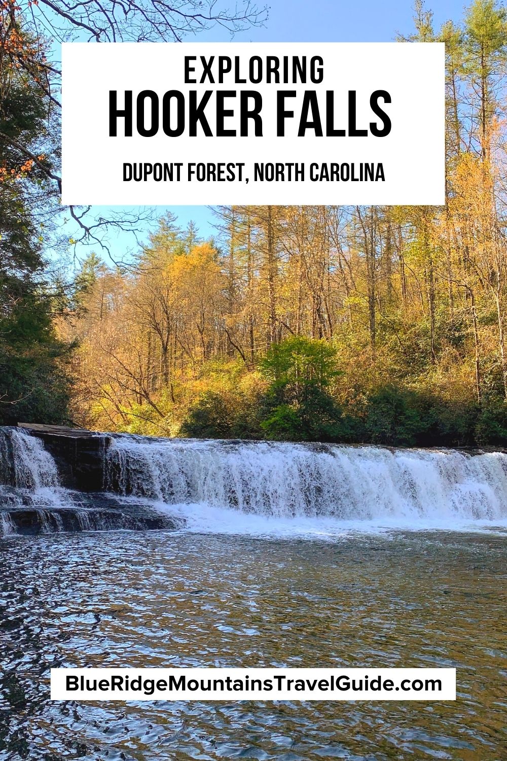
Located between Brevard and Hendersonville in DuPont State Recreational Forest, the Hooker Falls Trail is one of the shortest (.9 mile round-trip), easiest (164 feet of elevation gain), and most accessible waterfall hikes in Western NC.
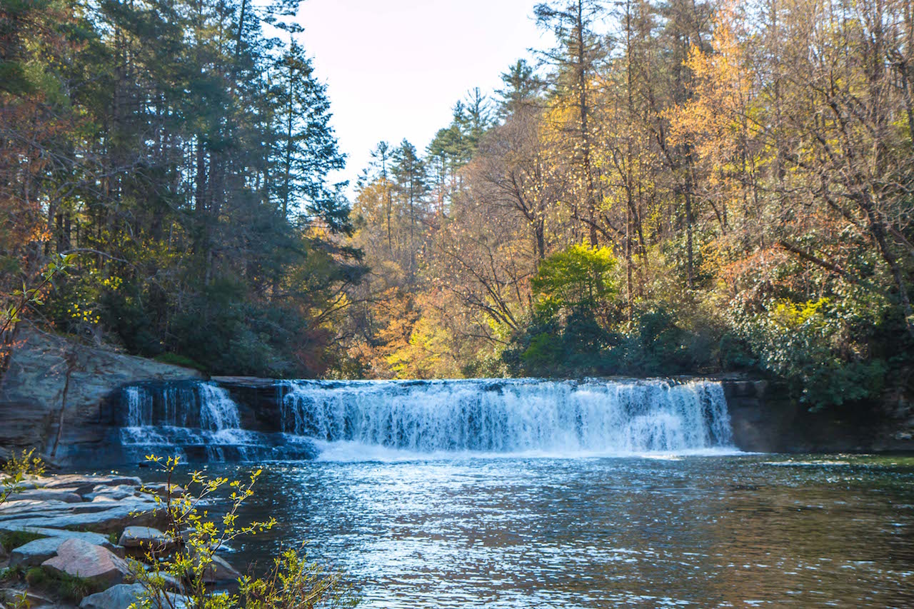
At just 12 or so feet in height, the waterfall is not particularly dramatic. And, thanks to one of the biggest natural swimming holes in NC, it’s also extremely popular, especially in the heat of summer.
So why was Hooker Falls NC one of the highlights of our recent visit to Hendersonville? Because it was the first of three beautiful waterfalls we saw during our visit to DuPont, providing an exceptional start to a beautiful day!
Read on to learn more about the history of Hooker Falls and DuPont State Forest, our step-by-step guide to the hiking trail, and driving directions from Brevard and Hendersonville.
Love North Carolina Waterfalls? Check out these guides!
The 20 Best Western North Carolina Waterfalls for Hiking
The 21 Best Blue Ridge Parkway Waterfalls in North Carolina
The 27 Best Waterfalls Near Asheville NC
The Top 10 Waterfalls Near Brevard NC (Transylvania County)
How to Get to Otter Falls Near Banner Elk NC
READ MORE: The Best Things to Do in DuPont State Forest, NC
HOOKER FALLS NC INFO
ADDRESS: DuPont State Recreational Forest, Staton Rd, Cedar Mountain, NC 28718
PHONE: 828-877-6527
COST OF ENTRY: Free
HOOKER FALLS HOURS: Sunrise to sunset.
WEBSITE: https://www.dupontstaterecreationalforest.com/
DUPONT STATE FOREST MAP: PDF
HIKING TRAIL: Easy, .9 mile in-and-out
AMENITIES: There is a restroom facility at the Hooker Falls trailhead parking lot. There are two designated accessible spaces in the partially paved lots at the east end of the trail off of Staton Road.
HOOKER FALLS/DUPONT STATE FOREST HISTORY
Part of the land now preserved by the DuPont State Recreational Forest was purchased by John Thomas Jr in 1799. He gave it to his three sons 14 years later.
One of them– Micajah– would go on to build a homestead, farm, and the Buck Forest Inn to serve travelers on the road between Brevard and Hendersonville.
Micajah was reportedly blinded by Union soldiers (who also burned down his home and Inn) near the end of the Civil War. When he died in 1883, he was buried in the Thomas Family Cemetery, one of two historic cemeteries that remain on the forest property today.
The Hooker Falls Trail will take you to another historic burial ground, the Hooker-Moore Cemetery. The Moore family owned the land around the waterfall in the early 1800s, and some sources suggest that Clinton Moore (who is buried in the cemetery) built a grist mill next to what is now known as Hooker Falls.
In 1882, the Moore family sold their parcel of land to the three Hooker brothers, which explains how Hooker Falls ultimately got its name.
By the early 20th century, numerous lumber mills were harvesting timber from the area (including the Carr Lumber Company in Pisgah Forest). Wildfires also occasionally burned large portions of the area west of the Little River.
The Coxe family, from nearby Asheville, leased 5000 acres of the forest in the 1940s. They built the Buck Forest Lodge near High Falls in 1941 as a hunting and fishing refuge for members of their Buck Forest Hunt Club.
The DuPont Corporation bought nearly 10,000 acres in the early 1950s, building plants for manufacturing silicon chips and x-ray film over the next few years. The company also initiated a forest management program, and continued to allow local mills to harvest some of the timber.
The 7600-acre tract that became the heart of DuPont State Recreational Forest was purchased by the state of North Carolina in 1996. Another 500 acres was added thanks to a purchase by the Conservation Fund NGO, while Sterling Diagnostic Imaging bought DuPont’s 2700-acre industrial complex.
After Sterling sold 2200 acres to a real estate development company in the late ’90s, environmental groups such as the NC Natural Heritage Trust Fund and Friends of DuPont State Forest fought to keep the falls public. Victory came in 2000, when NC Governor Jim Hunt used the state’s eminent domain to buy the land.
In the 21 years since, conservation efforts have steadily added more acreage to DuPont State Recreational Forest. Thousands of acres surrounding the forest remain in private hands, but have conservation easements protecting them.
READ MORE: Asheville NC History: From the Biltmore to 21st Century Boom
HIKING THE HOOKER FALLS TRAIL
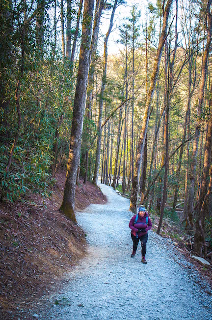
Departing from the same parking lot as the Triple Falls/High Falls Trail, the Hooker Falls Trail is one of the shortest, easiest, and most well-maintained hiking trails in Western NC.
The gently sloped path is wide enough for a small car or truck (approximately 5 feet), covered in a solid layer of gravel, and completely devoid of large rocks or roots.
Not having to worry about tripping leaves your eyes free to wander. The forest here is beautiful even in winter, with evergreens, hemlocks, and massive rhododendron on either side of the trail.
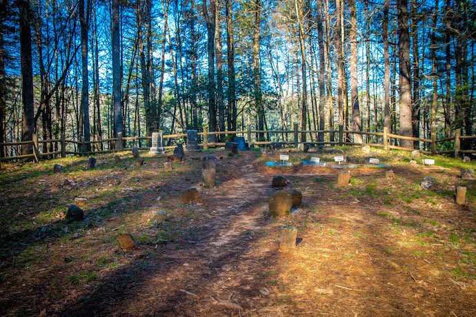
At around the .25-mile mark, you’ll notice a well-worn trail on the left that leads you to the Hooker-Moore Cemetery. Though many of the 65 or so graves here are unmarked, there are a few worth noting.
There’s Clinton Moore, whose family owned this land for nearly a century. There’s the grave of James Sentell, who deserted the Confederate Army in 1863 and later joined the Union Army before being killed in a skirmish.
Intriguingly, you’ll notice the more modern looking markers on the graves of Isaac Heath and his three daughters, who all died of diphtheria in 1861.
Heath buried his daughters (ages 5 to 12) personally to prevent others from being exposed to the illness, and was ultimately laid to rest right beside them. There’s an Isaac Heath Mountain Biking Trail in DuPont Forest today.
Back on the main trail to Hooker Falls, the path quickly becomes a bit more steep as it winds its way down deeper into the forest.
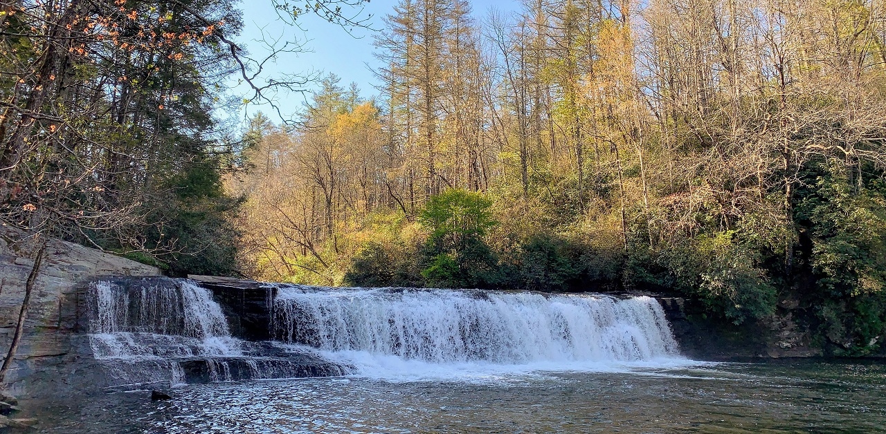
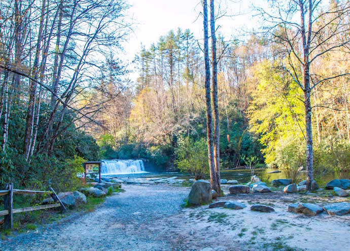
As you reach the bottom of the hill, the path emerges onto an open flat sandy area, with the gentle waters of the river directly ahead and Hooker Falls to your left.
READ MORE: The 20 Best Pisgah National Forest Hiking Trails in North Carolina
VIEWING HOOKER FALLS
As you make your way towards the rock-strewn shore leading to Hooker Falls, it’s worth taking a minute to look at the sign showing how this gorgeous recreational area was restored around 15 years ago.
The extensive logging of the forest led to massive erosion of the river bank at the base of Hooker Falls. So engineers worked to build up a foundation on which to lay the massive rocks near the base of the waterfall.
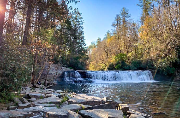
On summer days you’ll need to arrive early if you want to avoid the crowds. This is the only waterfall in DuPont State Forest where you can swim, making it one of the most popular Brevard NC waterfalls.
The tranquil pool at the base of the falls is deep enough for a nice cool dip, and the gentle current eventually leads floaters into Cascade Lake.
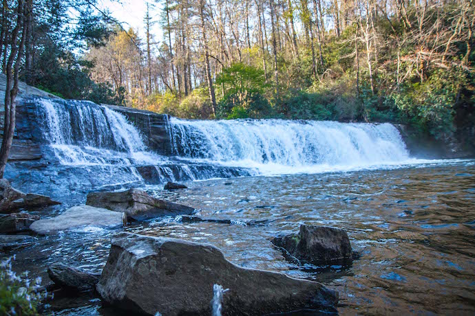
The waterfall itself isn’t all that high- around 12 to 15 feet. But it is very wide, with an impressively strong flow even when the area hasn’t had recent rains.
There’s lots of space on the left hand side for a picnic, sunbathing, or watching families (and dogs) splashing in the cool mountain water. And the forest provides plenty of shade on scorching hot summer days.
When you’re done, simply make your way back up the Hooker Falls trail the way you came. There are even changing rooms and restrooms in the parking lot.
Once you’re there, you can continue across the bridge over the Little River to do the 3+ mile Triple Falls/High Falls hiking trail, which we’ll discuss in a future post.
READ MORE: The Top 15 NC State Parks in the North Carolina Mountains
HOOKER FALLS DIRECTIONS
Directions From Brevard NC
Head north on S Broad St toward E Main St, then turn right toward State Rd 1504/Old Hendersonville Hwy. Take State Rd 1504/Old Hendersonville Hwy for 2.6 miles, then turn right onto Everett Rd.
Continue on Everett for 3.2 miles, then turn right onto Crab Creek Rd. Follow that for 2.9 miles and take a right onto Dupont Rd. In 1.2 miles, Dupont becomes Staton Rd.
Follow Staton for another 1.9 miles and you’ll see the Hooker Falls Access Area parking lot on your right.
Directions From Hendersonville NC
From Downtown Hendersonville, take 7th Ave west toward N Main St and turn left onto N Church St. In about half a mile, turn right onto Kanuga Rd.
Follow Kanuga for 3.9 miles, where it becomes Crab Creek Rd. Continue on Crab Creek for 7.1 miles, then turn left onto Dupont Rd. In 1.2 miles, Dupont becomes Staton Rd.
Follow Staton for another 1.9 miles and you’ll see the Hooker Falls Access Area parking lot on your right. –by Bret Love; all photos & video by Bret Love & Mary Gabbett

