
Located in the foothills of the Blue Ridge Mountains in Cartersville GA, the Etowah Indian Mounds State Historic Site is considered the most intact Mississippian culture site in the Southeastern US.
The prehistoric archaeological site contains one of the largest Indian mounds in North America. So it’s designated as a National Historic Landmark– one of just 49 historic sites in the state of Georgia to earn that distinction.
But it wasn’t until we visited the Museum of the Cherokee Indian in Cherokee NC, that we fully understood how significant the Etowah mounds are.
And not just to the Native American tribes in Georgia, but also to many of the indigenous people who live in the Southeast today.
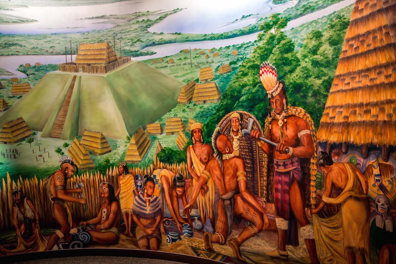
As you walk through the impressive museum dedicated to Cherokee culture & history, you’ll notice that only two of its rooms feature massive floor-to-ceiling murals.
One depicts the tragic Trail of Tears, the haunting (and, for countless indigenous people, deadly) 5,043-mile journey westward that came after the Indian Removal Act of 1830.
The other depicts the Etowah mounds as they must have looked centuries ago, before European settlers, the gold rush, and land lotteries pushed most of the Cherokee Indians in Georgia out.
Read on to learn more about the 1000-year history of the largest Indian mounds in Georgia, as well as an in-depth guide to exploring the Etowah mounds, archaeological museum, and hiking trails.
READ MORE: 25 Awesome Activities to Experience Fall in Georgia

Etowah Indian Mounds Historic Site Info
ADDRESS: 813 Indian Mounds Road SE, Cartersville GA, 30120
PHONE: 770-387-3747
HOURS: Open 7 days a week from 9 AM to 5 PM (the Etowah Mounds area closes at 4:30 PM). Closed on Thanksgiving, Christmas & New Year’s Day.
ENTRY FEES:
- Adults (ages 18–61): $6.00
- Seniors (ages 62+): $5.00
- Youth (ages 6–17): $4.00
- Youth Groups: $3.50 per person
- Children (under 6): $2.00
DIRECTIONS FROM ATLANTA: Head north on I-75 to exit 283 toward Emerson. Use any lane to turn left onto Old Allatoona Rd SE.
Follow that road for 0.8 miles, then continue onto GA-293 N for 0.1 miles. Take a slight left onto Old Alabama Rd SE and follow it for 1 mile, then use any lane to turn left to stay on Old Alabama Rd SE.
In 3.1 miles, turn right onto Douthit Ferry Rd, then go 0.6 miles and make a right onto Indian Mounds Rd. In 0.9 miles, you’ll make a sharp right into the Etowah Indian Mounds State Historic Site.
Want to explore other North Georgia State Parks & Historic Sites?
Check out these great guides!
The 15 Best North Georgia State Parks & Historic Sites
Things to Do in Black Rock Mountain State Park
Things to Do in Moccasin Creek State Park
Things to Do in Unicoi State Park & Lodge
Things to Do in Vogel State Park
Things to Do at James H Floyd State Park
Etowah Indian Mounds History
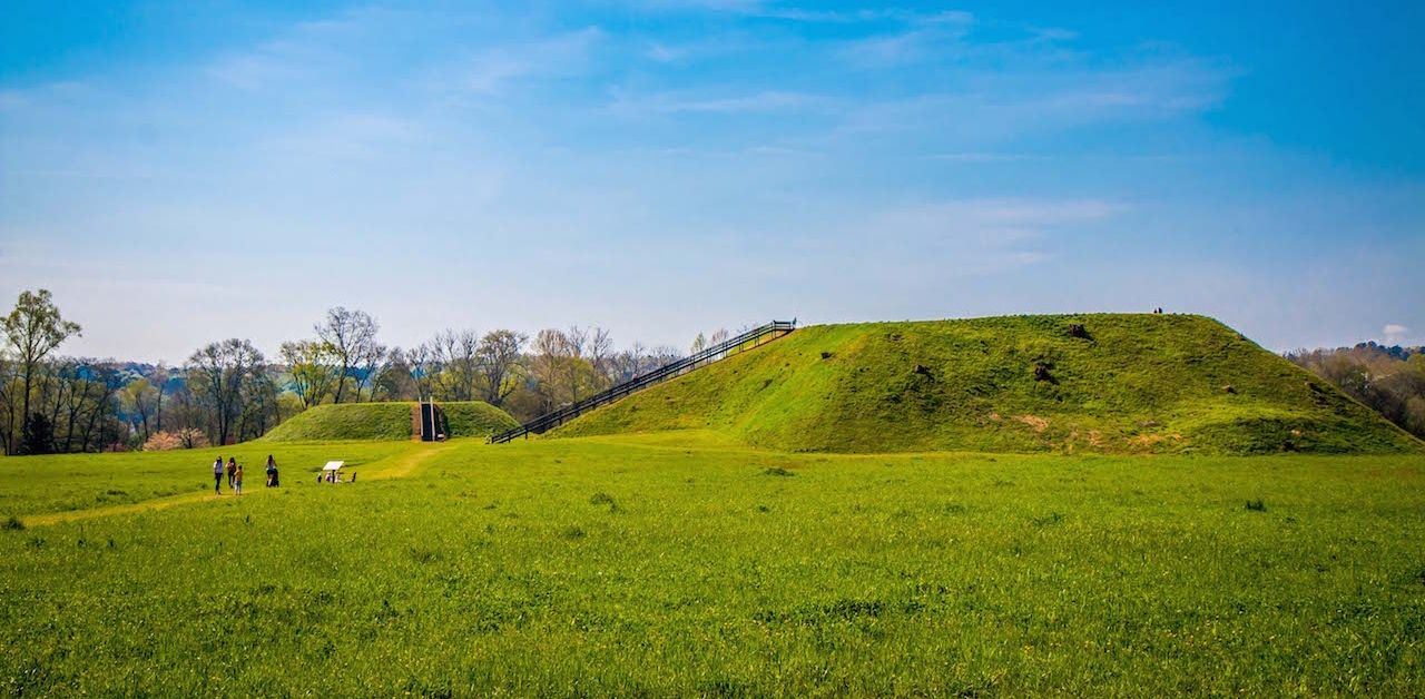
Located on the north shore of the Etowah River in Cartersville, the 54-acre Etowah Indian Mounds site features the largest Indian mounds in Georgia.
Studies in the late 20th century showed that the mounds were built in three phases, from 900 to 1550 AD.
Like the Ocmulgee Mounds in Macon, they were originally inhabited by indigenous peoples of the South Appalachian Mississippian culture, the prehistoric ancestors of the Muscogee Creek people.
The site includes six earthen mounds, an open plaza that functioned as the town center, borrow pits, and a defensive ditch surrounding the mountain town.
The dirt from the borrow pits and ditch were used to build the earthen mounds, which served as platforms for dwellings for the chief/priest, temples, and a mortuary ground for elite members of the society.
Originally known as Italwa (the Muscogee word for “town”), the ancient city was visited by Spanish explorer Hernando de Soto and 1,000 of his men in 1540.
READ MORE: The 15 Best Scary Escape Rooms in Georgia

The population of Native Americans in Georgia was quickly devastated by diseases brought by the European immigrants, such as smallpox and the measles, to which they had no natural immunity.
By the 19th century, most European settlers believed that the Etowah mounds had been built by the Cherokee people, who were dominant among the Indian tribes in Georgia by that time.
But subsequent archaeological digs found artifacts that clearly proved that the Mississippian mounds pre-dated the arrival of the Cherokee in the state in the 1700s.
Colonel Lewis Tumlin won the rights to the Etowah land in the Georgia Land Lottery of 1832, and his descendants farmed these sacred grounds until 1953, when a portion was sold to the State of Georgia for conservation.
The site ultimately earned recognition as a National Historic Landmark in 1964, and the Etowah Indian Mounds remain a widely revered site among the Muscogee Nation (now based in Oklahoma), the Poarch Band of Creek Indians (in Alabama), and the Cherokee Nation today.
READ MORE: Exploring the Dark History of the New Echota Historic Site in Calhoun GA
Exploring the Etowah Indian Mounds

Mound A
Etowah Mound A is the largest of the Indian mounds in Georgia. It covers 3 acres at its base, with a 63-foot staircase that leads you to the top.
This platform mound was once home to a great temple that housed the chief and his family. This is also where the chief presided over ceremonies and festivals that took place in the central plaza below.
From this lofty perch, you can view the outline of the plaza, the modern fence where the defensive ditch once served as protection, and the forest along the Etowah River where the people once hunted wild game.
The top of the mound was actively farmed by the Tumlin family in the 19th century, and two ancient dog statues were uncovered here in the 1930s.
But, as with approximately 90% of the Historic Site, Mound A has never been subject to a full scientific excavation.
READ MORE: The 10 Best Fairs in Georgia
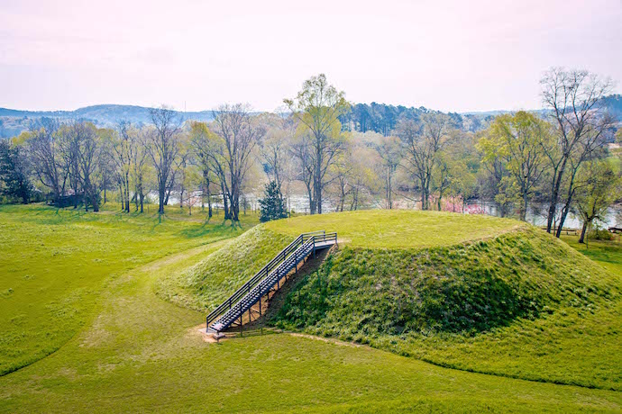
Mound B
From the top of Mound A, you can get a great bird’s-eye view of Mound B, which is much smaller at 25 feet high.
This secondary mound was also a temple platform, and has never been fully excavated.
But remnants of a large building, which may have been a council house or the residence of a lesser chief or priest, were discovered.
A test pit dug on the base of the mound revealed both human burials and trash pits that contained the remains of deer, turtles, fish, and plants.
This mound is the closest to the Etowah River, which stretches 164 miles from headwaters west of Helen GA, into Lake Allatoona, and southwest into Alabama’s Mobile Bay.
READ MORE: The 15 Best Lakes in the North Georgia Mountains

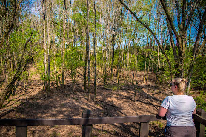
Mound C
It may be the smallest of these Indian mounds near Atlanta, but the 10-foot-tall Mound C is the only one at Etowah that has been completely excavated (and later reconstructed).
Studies showed that the Etowah Indian mounds were built in stages, with changes in building structures, fences, and even burial styles over time.
The 350 burials unearthed in Mound C told scientists a lot about the South Appalachian Mississippian classes of people, style of dress, diet, diseases, and more.
Most of the Native American artifacts you’ll see in the Etowah Archaeological Museum were found here, including the famous Georgia marble effigy statues (which we’ll discuss later).
Exploring the Etowah Hiking Trails

Interpretive Trail
The Etowah Indian Mounds State Historic Site offers 3 short, easy hiking trails, ranging in length from 3/8-mile to just over 1 mile.
The Interpretive Trail is the shortest, but also the most informative.
As you exit the museum, you’ll see a wattle and daub house reminiscent of the hundreds of huts that covered the grounds around 1250 to 1325 AD.
Reconstructed in 2008 by American Indians and volunteers, the structure uses woven green cane and a red Georgia clay mixed with grass and water.
From there, the trail crosses over the defensive ditch that surrounded the ancient town on 3 sides.
Dug with handmade stone tools over the course of 50 years, the ditch was 9 to 10 feet deep and had 12-foot high wooden palisades for defensive purposes.
The trail then crosses the open area where thousands of Etowah Indians lived, leading visitors to the massive mounds and the plaza.
This was the community center, where there was a market for trade and a field for playing inter-tribal games such as stickball (which eventually evolved into lacrosse).

River Walk Nature Trail
The 5/8-mile River Walk Nature Trail begins in the area where the Interpretive Trail ends: On the beautiful banks of the Etowah River, where an ancient fish trap dam can be seen in summer and fall when the water is low.
Also known as a fishing weir, these traps were made out of stone and river rocks, which were constructed in a v-shape with an opening for traps downstream.
One explorer wrote of Native Americans in Georgia using boughs on ropes to herd bass, catfish, and drum into the dams, sometimes catching up to 1,000 fish a day.
Heading west along the river bank, the Nature Trail enters a lovely forest lined with North GA wildflowers.
In Etowah’s heyday, residents would forage the area for chestnuts, walnuts, persimmons, mushrooms, freshwater mussels, and a native holly bush whose leaves were brewed into a drink imbibed in ritual purification ceremonies.
The trail then turns north, where it merges with the Perimeter Trail.
Perimeter Trail
The 1 1/8-mile Perimeter Trail is the longest of the Etowah trails, circling the boundaries where the Defensive Ditch protected residents from attacks by a rival Mississippian tribe from Moundville (in what is now Alabama).
The ditch was protected by an outer band of nut trees, which both supplied food and prevented the enemy from being able to shoot flaming arrows into the town.
The ditch also helped with drainage during major floods.
There were numerous guard towers for archers along the palisades, which were spaced about 80 feet apart.
The Perimeter Trail connects with the Nature Trail at the Borrow Pit Overlook on the town’s northwest side.
This is where countless thousands of baskets full of soil used in construction of the Etowah mounds were dug.
READ MORE: The 20 Best North Georgia Waterfalls (& How to Get to Them)
Exploring the Etowah Archaeological Museum

The earliest archaeological tests of the Etowah Indian Mounds were conducted for the Smithsonian Institution in the 1880s.
More than 60 artifacts from that dig remained hidden in vaults for 100+ years, until the “From Clay to Copper: Minerals and Artifacts of Etowah” exhibit came to Cartersville’s Tellus Museum in 2016-2017.
Warren K. Moorehead (who is known as “the Dean of American archaeology”) led the 4-year excavation of Mound C starting in 1925.
He uncovered a vast array of Mississippian cultural artifacts that helped to define the Southeastern Ceremonial Complex and greatly improved our understanding of pre-Contact Native American artwork.
Visiting the Etowah Archaeological Museum today, you’ll see hundreds of those artifacts on display.
Elite members of Etowah society were buried with copper tools, weapons, and ornamental plates, and dressed in brightly colored clothing with ornate patterns.

The Etowah Indian Mounds museum features lots of artifacts that show how the Mississippians adorned themselves with feather ear ornaments, shell beads, and paint.
There are also numerous exhibits featuring items ranging from artfully decorated pottery and monolithic stone axes to copper jewelry, shell gorgets, and other artifacts.
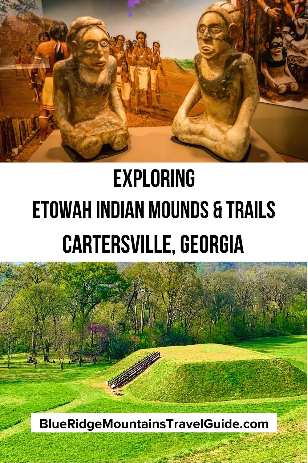
You’ll see numerous clay figurines and stone statues of young kneeling women (which are thought to represent an Earth Mother or fertility goddess), and copper plates featuring dancing warriors.
But the most impressive exhibit features two hand-carved stone effigies of a cross-legged man and kneeling woman, both with elaborate hairstyles.
Weighing around 125 pounds each and showing original pigments, they’re proof that this ancient indigenous culture was remarkably advanced, both artistically and technically. –by Bret Love; all photos by Bret Love & Mary Gabbett

