

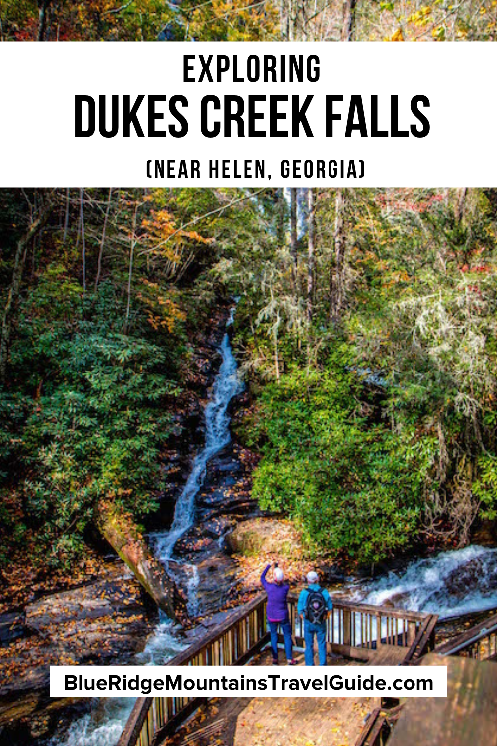
Dukes Creek Falls Recreation Area Info
ADDRESS: 1699 Richard Russell Hwy, Helen GA 30545
PHONE: 706-745-6928
COST OF ENTRY: $4 per vehicle per day.
DUKES CREEK FALLS HOURS: Sunrise to sunset.
WEBSITE: https://www.fs.usda.gov/recarea/conf/recarea/?recid=10509
HIKING TRAIL: Moderate difficulty, 2.5 miles round trip.
AMENITIES: The hiking trail’s first 1/10-mile is wheelchair-accessible, leading to a viewing platform. From there, anyone can get a view of Dukes Creek Falls without hiking the entire trail. There are also restrooms and 4 picnic tables with grills and trash cans nearby.
Love North GA Waterfalls? Check out these great guides!
The 20 Best North Georgia Waterfalls (& How to Get to Them)
The 10 Best Waterfalls Near Helen GA
The 10 Best Waterfalls Near Blue Ridge GA
How to Get to Anna Ruby Falls Near Helen GA
How to Get to Horse Trough Falls in Helen GA (Upper Chattahoochee River Campground)
How to Get to Helton Creek Falls in Blairsville GA
How to Get to Hemlock Falls at Moccasin Creek State Park
How to Get to Minnehaha Falls on Lake Rabun
How to Get to Panther Falls & Angel Falls at Lake Rabun Beach
How to Get to Long Creek Falls in Blue Ridge GA

Dukes Creek & Helen GA History
Like the majority of the North Georgia mountains (and southern Appalachia as a whole), much of what we now call Helen GA was originally Cherokee and Creek Indian territory.
The national forest that surrounds Dukes Creek was named after the Chattahoochee River. Chatta means stone and ho chee means flowered or marked in the Muskogean dialect. Georgia’s European settlers simply adopted the name used by natives.
Dukes Creek made White County famous back in 1828, when the first gold was found along the 8.76-mile creek. That discovery, plus one in neighboring Lumpkin County, led to the Georgia Gold Rush of 1829 (which preceded California’s boom by 20 years).
By the mid-1800s, North Georgia’s gold prospects had dried up. And by the turn of the century this area was being deforested for a timber mill in Helen at an unsustainable rate.
In 1936, the Chattahoochee National Forest was created in an effort to preserve the forest and protect the area’s crucial watershed and the numerous wildlife species that inhabit it.
READ MORE: The 20 Best Things to Do in Helen GA

White County began to emerge as a budding tourist destination in the mid-1950s. It was 20 years after the Civilian Conservation Corps (CCC) built a camp along Smith Creek, and businessman Charlie Maloof convinced the state to build a new highway to Hiawassee.
Maloof, who eventually became mayor of Helen GA, proposed building a new lodge north of the city, and the 278-acre White County Area State Park was opened in 1954.
After damming Smith Creek to create a Unicoi Lake, Unicoi State Park was born in the mid-’60s. And with the groundbreaking for the Unicoi State Park Lodge (the first lodge in any of the North Georgia State Parks) in 1982, Helen began to emerge as a major tourist attraction.
Dukes Creek Falls is one of four popular waterfalls near Helen GA, with the others being Anna Ruby Falls, DeSoto Falls, and Raven Cliff Falls.
And with its prime location along the Richard B. Russell Scenic Highway near Raven Cliff Falls and Helton Creek Falls, Dukes Creek is widely regarded as one of the best waterfalls in North Georgia for day hiking.
READ MORE: The 15 Best Rental Cabins in Helen GA

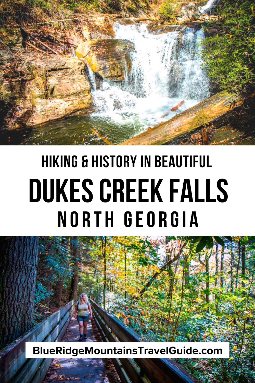
Hiking the Dukes Creek Falls Trail
One of the few waterfalls in Georgia we’ve visited that was at least somewhat wheelchair-accessible, the Dukes Creek Falls trail is a moderately difficult 2-mile round-trip hike that is extremely kid- and dog-friendly.
The Dukes Creek trailhead starts from the parking lot, which has a $4 fee and offers an exceptional view of the exposed rock outcroppings of nearby Yonah Mountain.
The first 1/10th of a mile is paved and relatively flat, leading to an ADA-accessible viewing platform.
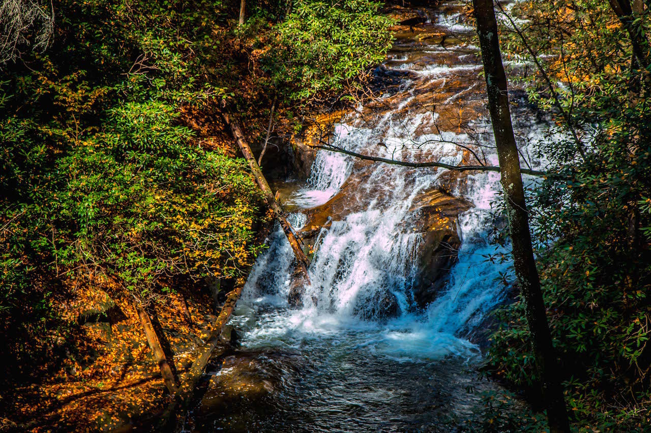
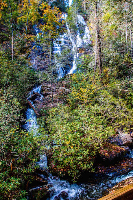
Here you can get your first glimpse of the Helen waterfall’s precipitous 150-foot drop, framed by lush foliage with a massive mountain in the background.
READ MORE: 10 Fun, Festive Ways to Celebrate Christmas in Helen GA

From there the trail trades pavement for well-packed dirt, widens enough to fit a small truck, and drops in elevation via a series of stairs and platforms.
At .3 miles you can take a brief detour to see picturesque Davis Creek (which really dazzles in the the golden light of the morning sun), or head left to descend deep into the lush valley.
There are 3 sharp switchbacks over the course of one mile, with the sounds (and several sightings) of the beloved GA waterfalls along the way.
After spending time soaking in the exceptional views at the base of Dukes Creek Falls, you’ll make your way back up the hill, completing the 2-mile waterfall hike.
READ MORE: The 10 Best Restaurants in Helen GA for Breakfast, Lunch & Dinner
Dukes Creek Falls Viewing Platforms
Dukes Creek Falls is unique among the falls in North Georgia for a number of reasons.
Firstly, the trail is extremely well-developed and maintained, wheelchair-accessible, kid-friendly, and wide enough for social distancing.
Secondly, with four viewing platforms (one at the top, three at the base) plus glimpses of various cascades along the trail, it ranks alongside Amicalola Falls among the most visible waterfalls in GA.
But perhaps the most interesting thing about Dukes Creek Falls is the fact that the 150-foot drop you can see at numerous places along the hike isn’t really Dukes Creek at all.
It’s actually Davis Creek, which tumbles over the mountain’s precipice and makes its way down the jagged, rocky cliffside before feeding into Dukes Creek, right below the lowest of the three observation decks.
READ MORE:The 20 Best Places to Celebrate Christmas in Georgia

To see the Dukes Creek waterfall, you’ll make your way to the observation platform on the far right as you make your way to the bottom of the hiking trail.
There you can see Dukes Creek’s more modest drop, which no more than 15-20 feet tall and about the same width.
It’s undoubtedly a gorgeous spot, but it’s really the confluence of the two creeks and the beauty of the national forest that surrounds them that makes it so special.
Also, note that the paths to these platforms are fairly narrow, and quite a few people who were there when we visited were NOT wearing masks or mindful of social distancing.
If you’re keen on avoiding crowds, early morning or late afternoon weekday visits may be best, even in the off-season.
Due to the immense popularity of the Dukes Creek Falls swimming holes, I personally wouldn’t recommend visiting the area on weekends in peak summer season at all.
READ MORE: The 20 Best Places to Live in the Georgia Mountains

Dukes Creek Falls Directions
Directions to Dukes Creek From Helen, GA (5.4 miles)
From downtown Helen, head west on GA-17 N/GA-75 N/N Main St/Unicoi Turnpike toward White Strasse.
After 1.3 miles, turn left onto GA-75 Alt N and follow it for 2.3 miles. When you see Smithgall Woods State Park on your left, make a right onto GA-348 W.
This road is also known as the Richard B. Russell Scenic Highway, which has several stunning overlooks along its 14 miles of winding curves through the forest.
In 1.7 miles, you’ll see the sign marking the entrance to the Dukes Creek Falls Recreation Area on the left. Note that Raven Cliff Falls (another of our favorite Helen waterfalls) is just a mile further north on GA-348 W.
READ MORE: The 15 Best Day Hikes on the Appalachian Trail in Georgia
Directions to Dukes Creek From Blairsville, GA (20.9 Miles)
From downtown Blairsville, head south on US-129/US-19 for 6.9 miles to State Route 180.
Turn left onto State Rte 180 and follow it for .9 miles, then turn right onto GA-348 E (a.k.a. the Richard B Russell Scenic Highway).

Comments are closed.