
[Updated September 21, 2021] From Amicalola Falls and Anna Ruby Falls to Raven Cliff Falls and Panther Creek Falls, the Blue Ridge mountains offer an excellent array of North Georgia waterfall hikes.
But of all the waterfalls in Georgia, few offer quite as much of a picturesque bang for your buck as Minnehaha Falls, GA.
At just .4-mile round trip, this short, easy waterfall hike near Helen and Clayton offers maximum picturesque payoff for minimal investment of time and energy.
Though the Minnehaha waterfall trail can get a bit crowded during busy weekends in peak season, it’s practically empty early on weekend mornings and during the week.
And since it’s located on the southern shore of Lake Rabun, it’s easy to combine the Minnehaha Falls hiking trail with the 1.75-mile Angel Falls and Panther Falls trail (which is just 3.5 miles away) in the same morning.
So here’s our guide to hiking Minnehaha Falls, Georgia (there’s another one in Minnesota), including driving directions, a little history, and an overview of the hike itself.
READ MORE: 101+ Things to Do in North Georgia
Minnehaha Falls, GA Info
ADDRESS: Off Bear Gap Road in Tallulah Falls GA 30573
PHONE: 706-782-3320
COST OF ENTRY: Free (including free parking)
MINNEHAHA FALLS HOURS: Always open
WEBSITE: https://www.fs.usda.gov/recmain/conf/recreation
Love North GA Waterfalls? Check out these great guides!
The 20 Best North Georgia Waterfalls (& How to Get to Them)
The 10 Best Waterfalls Near Helen GA
The 10 Best Waterfalls Near Blue Ridge GA
How to Get to Horse Trough Falls in Helen GA (Upper Chattahoochee River Campground)
How to Get to Anna Ruby Falls Near Helen GA
How to Get to Helton Creek Falls in Blairsville GA
How to Get to Panther Falls & Angel Falls at Lake Rabun Beach
How to Get to Long Creek Falls in Blue Ridge GA
How to Get to Sea Creek Falls in Suches, GA
Minnehaha Falls/Lake Rabun History
Minnehaha Falls is located in the Chattahoochee National Forest, near the western end of Lake Rabun in Tallulah Falls, GA.
This popular North Georgia waterfall’s name comes from the Native American word for “waterfall.” As with most of GA’s Blue Ridge region, this was Cherokee land until European settlers arrived.
The 835-acre Lake Rabun was the third in a series of six lakes (after Lake Burton and Lake Seed) that follow the Tallulah Rivers natural course.
All were built by what is now known as Georgia Power (then the Georgia Railway & Power Company) in the early 20th century to provide hydroelectric energy for Atlanta.
The filling of Lake Rabun began in 1915, after the construction of Mathis Dam was completed. Located at around 1689 feet above sea level, the lake encompasses 25 miles of shoreline stretching across a 10-mile section of the river.
Today, the lake is known as a favorite weekend getaway for Georgia’s wealthy elite. And though GA Power does lease some lots for housing, the homeowners involved in the Lake Rabun Association have largely resisted attempts to commercialize the quaint area.
As a result, this is one of the most pristine and picturesque lakes in Rabun County, with smaller crowds than you see at other tourist hotspots near Clayton GA.
READ MORE: The Top 10 Treehouse Rentals in the Georgia Mountains
Hiking the Minnehaha Falls Trail
Not to be confused with the 50-foot waterfall in Minneapolis, Minnehaha Falls, GA is located off the unpaved Bear Gap Road, just across from the shore of Lake Rabun .
Of all the waterfall hikes in North Georgia, the Minnehaha Falls Trail is one of the easiest, at just .4 miles out and back. In fact, the hardest thing about hiking to Minnehaha Falls is simply finding the trailhead.
You’ll find driving directions to Minnehaha Falls below, but it’s important to note that Bear Gap Rd and Low Gap Rd appear to be one in the same.
We completely missed the turn the first time, and even Google Maps seemed confused. So just go slow and make sure you download a map to your phone in case you lose your wifi signal.
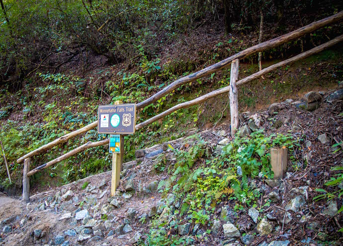
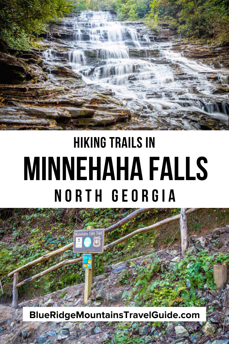
You’ll see the small Minnehaha Falls Trail sign, marked with the number 147 and a green diamond, on your right as you round a big turn in a residential area. Note that the parking area is VERY small, so get there early if you’re hiking Minnehaha Falls on a weekend in peak season.
Once you climb the set of wooden steps at the start, the trail is very easy, both kid- and dog-friendly. The gradual climb in elevation feels gentle, with the soothing sounds of Falls Creek gurgling to your right.
You’ll likely encounter mud if it has rained recently, and there are some roots along the path. But the evergreen, rhododendron, and hardwood forest is absolutely gorgeous.
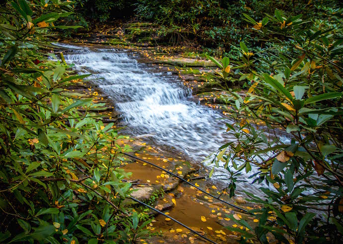
There are also a few little side trails where you can make your way down to some of the lower falls along the way, including the lovely little terraced section pictured above.
READ MORE: The 15 Best North Georgia Mountains for Hiking
The Minnehaha Falls Trail Grand Finale
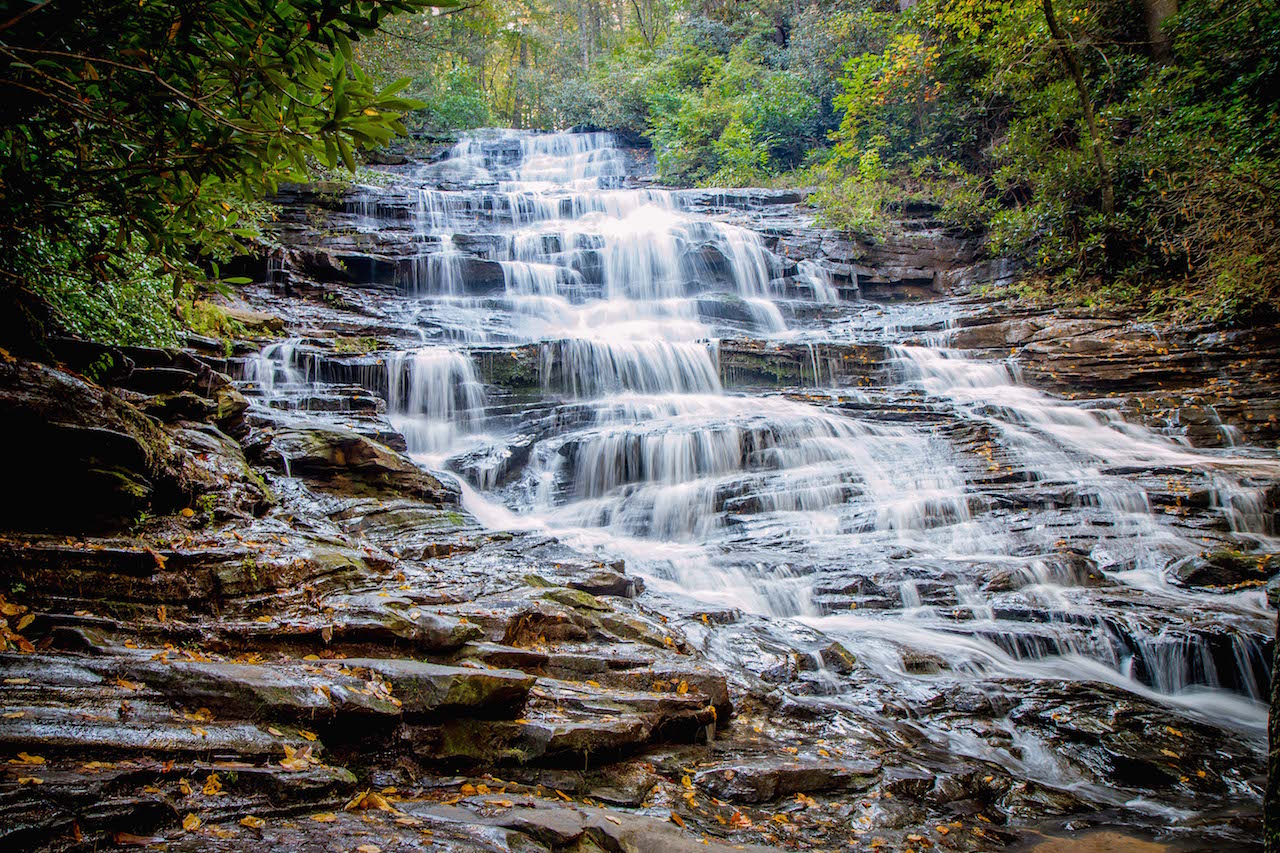
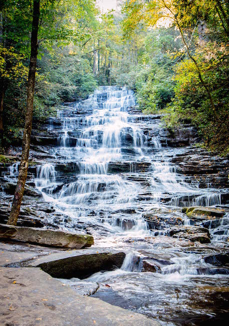
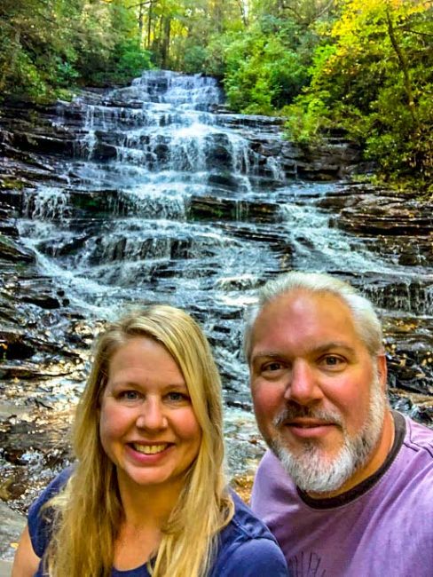
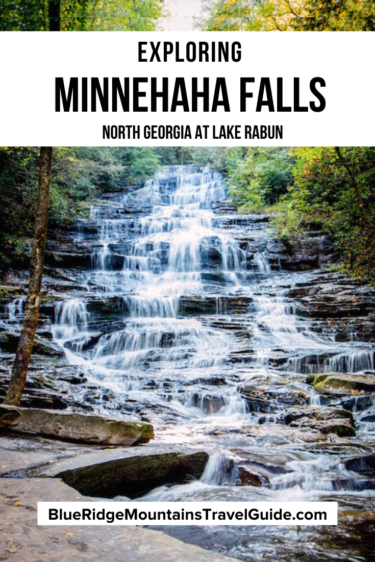
There’s a reason why Minnehaha is one of the most beloved waterfalls in North Georgia, and it will become readily apparent the moment you crest the final hill.
After trekking just .2 miles through the beautiful forest, you’re treated to a spectacular view of the 60-foot waterfall in its full glory.
The expansive area at the base of the falls allows for exceptional views from multiple angles, with the crest of the waterfall towering above.
Angled terraces create dramatic water action as Falls Creek descends (especially after recent rains), and the big boulders at the base add dynamic accessories to the landscape.
The only downside is that, unlike some of the other great North Georgia waterfalls, there’s simply not enough depth to swim at the base of Minnehaha Falls.
It is perfect for wading though, with cool mountain temperatures even in summer. But please exercise extreme caution, as the water can move quickly and the rocks are quite slippery.
Lastly, there is a trail leading up to the top of the falls, but by all accounts it is very steep, very slippery, and not well-maintained. Other hikers we spoke to advised against it, so we simply descended the trail the way we came after soaking in Minnehaha’s splendor.
READ MORE: Vogel State Park: Camping, Hiking & History in North Georgia
Minnehaha Falls Directions
Directions to Minnehaha Falls From Clayton, GA (15.8 Miles)
From S Main St in downtown Clayton, head south on US-23 S/US-441 S for 5.9 miles.
Turn right onto the Wiley Connector for .1 mile, then take a left onto S Main St/Old 441 S. Follow Old 441 S for 1.5 miles, where it will turn into Lake Rabun Rd.
Continue straight on Lake Rabun Rd for 6.3 miles, then take a left onto Bear Gap Rd/Low Gap Rd.
Follow the gravel road for approximately 1.6 miles and look for the small Minnehaha Falls Trail sign and staircase pictured above on the right hand side of the road.
READ MORE: Fall in the Mountains of North Georgia: Best Places to See Fall Colors
Directions to Minnehaha Falls From Helen, GA (23.8 Miles)
From downtown Helen, head west on GA-17 N/GA-75 N/N Main St/Unicoi Turnpike toward White Strasse.
In approximately one mile, turn right onto GA-356 E and follow it for 10.8 miles, passing Unicoi State Park & Lodge along the way.
Turn left onto GA-197 N, and follow that road towards Lake Burton for 3.1 miles until you reach Burton Dam Rd.
Take a right, and follow Burton Dam Rd for 2.9 miles, where it changes names to Seed Lake Rd. Continue straight for another 4.4 miles, then turn right onto Bear Gap Rd/Low Gap Rd.
Follow the gravel road for approximately 1.6 miles and look for the small Minnehaha Falls Trail sign and staircase pictured above on the right hand side of the road. –by Bret Love; photos & video by Bret Love & Mary Gabbett
Best Clayton, GA Hotels & Cabin Rentals
Mountain Aire Cottages & Inn – Excellent location and quiet.
White Birch Inn – Get the celebrity treatment with world-class service.
Kingwood Country Club & Resort – Peaceful with beautiful scenery.
Pet-Friendly Cozy Cabin with Views By Black Rock – Entire vacation home • 2 bedrooms • 1 living room • 3 bathrooms • 1464 ft²
Heaven’s Rest Vacation Home – Entire vacation home • 4 bedrooms • 3 bathrooms • 2896 ft² • 6 beds (1 full, 1 king, 1 sofa bed, 3 queens)

Comments are closed.