
[Updated October 20, 2021] Between the historic downtown area, delicious restaurants, wineries, gorgeous scenery, outdoor activities, and unique places to stay, it’s no wonder why locals and visitors alike recognize Blue Ridge as one of the best small towns in the state of Georgia.
This tiny North Georgia mountain town offers countless attractions within its city limits, but also provides a great home base for exploring the Chattahoochee-Oconee National Forest.
There are magnificent mountains, glistening mountain lakes, scenic hiking trails, and numerous beautiful waterfalls hidden throughout the surrounding areas.
So whether you’re looking for a quick afternoon excursion or a full-day hiking adventure, read on for our list of the 10 best waterfalls near Blue Ridge GA, which we’ve arranged in order of geographical distance from town!
READ MORE: 101+ Things to Do in North Georgia
Love North GA Waterfalls? Check out these great guides!
The 20 Best North Georgia Waterfalls (& How to Get to Them)
The 15 Best Waterfalls Near Helen GA
How to Get to Horse Trough Falls in Helen GA (Upper Chattahoochee River Campground)
How to Get to Anna Ruby Falls Near Helen GA
How to Get to Dukes Creek Falls Near Helen GA
How to Get to Helton Creek Falls in Blairsville GA
How to Get to Hemlock Falls at Moccasin Creek State Park
How to Get to Minnehaha Falls on Lake Rabun
How to Get to Panther Falls & Angel Falls at Lake Rabun Beach
How to Get to Long Creek Falls in Blue Ridge GA
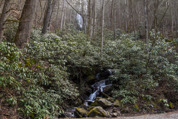
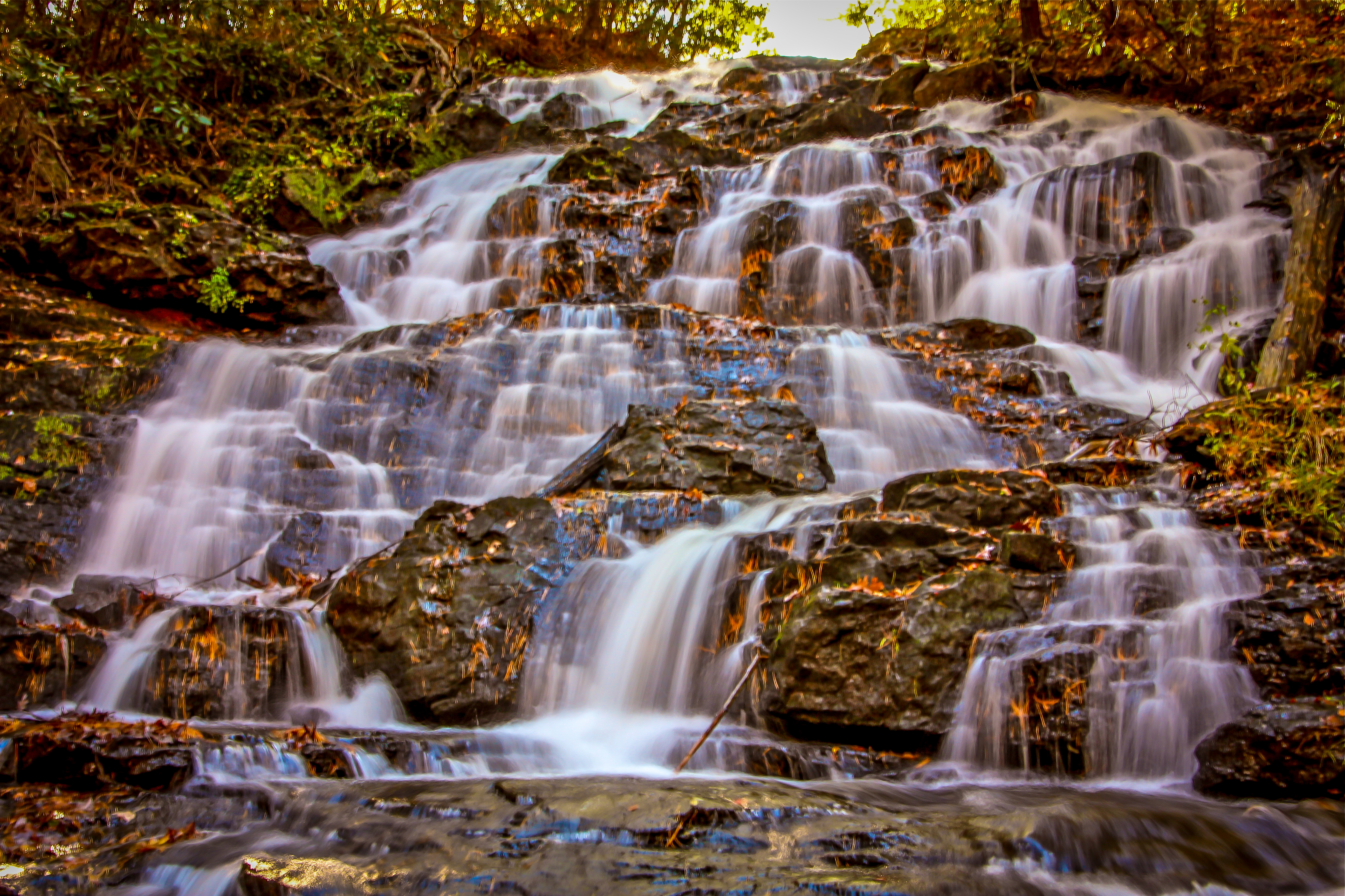
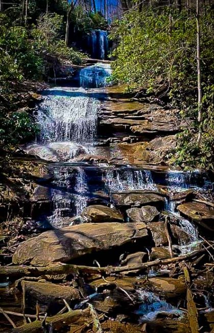
Falls Branch Falls
Cherry Log, GA
Distance from Blue Ridge: 12.4 miles
Level of difficulty: Easy
Trail Length: 0.9 miles round-trip
Elevation Gain: 200 feet
Just about a 20-minute drive from downtown Blue Ridge, the Falls Branch Falls Trail explores a beautiful mossy forest before leading you to the mesmerizing double cascades of the waterfall.
Perfect for all different levels of ability, this short half-mile trail takes hikers along the Benton MacKaye Trail, which is lined with beautiful wildflowers such as rhododendron and mountain laurel.
The trail will ultimately lead you to a wooden observation platform, where you can get amazing views and photo opportunities of the multi-tiered, 75-foot waterfall.
After taking in the sights, you can continue along the Benton MacKaye Trail to extend your adventure, or simply retrace your steps back to the parking lot for a quick, yet scenic trek.
READ MORE: The 20 Best Things to Do in Blue Ridge, GA
Noontootla Falls
Newport, GA
Distance from Blue Ridge: 22 miles
Level of difficulty: Moderate
Trail Length: Under a mile from the road
Located just off of Forest Road 58 in Fannin County, in the vast Chattahoochee National Forest, Noontootla Falls is an 80+ foot, multi-tiered North Georgia waterfall.
If you travel on Forest Road 58 for just over two miles, you’ll reach a small tributary on the right that falls off of the mountain and goes under the road by a culvert.
Just make sure to keep your eyes peeled, because it’s really easy to miss.
From the north side of the creek, it’s a short trek (but a fairly steep and slippery one) to an opening where you can see the hidden waterfall.
READ MORE: The Top 10 Treehouse Rentals in the Georgia Mountains
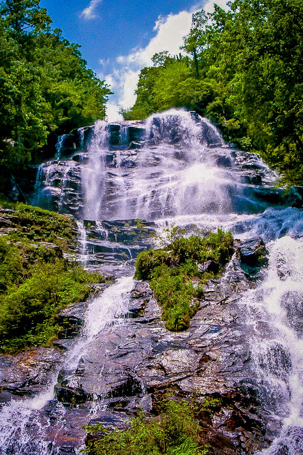
Amicalola Falls
Dawsonville, GA
Distance from Blue Ridge: 34.5 miles
Level of difficulty: Moderate
Trail Length: 2 miles
Elevation Gain: 784 feet
One of the most popular waterfalls near Blue Ridge Georgia, Amicalola Falls is the tallest waterfall in the state, reaching a total height of 729 feet.
There are different trails that give you access to the falls, including the wheelchair-accessible West Ridge Falls Access Trail and the East Ridge Trail, which is just one mile long.
But the most popular trail for viewing the falls is the two-mile Amicalola Falls Loop Trail.
This path guides you up a series of metal-grate stairs along the side of the falls to a viewing platform, where you can admire the rushing water as it tumbles over seven different cascades.
You can head back down the same way you came to complete your adventure, or continue past the falls to explore more of Amicalola Falls State Park.
READ MORE: The 13 Best Restaurants in Blue Ridge GA
Trahylta Falls
Blairsville, GA
Distance from Blue Ridge: 32.9 miles
Level of difficulty: Easy
Trail Length: 1.1 miles
Elevation Gain: 75 feet
Situated in one of the oldest North Georgia State Parks, Trahlyta Falls is a 110-foot-tall cascading waterfall surrounded by lush Chattahoochee National Forest hiking trails.
To access the falls, take the Trahylta Lake Trail, which is one of the easiest and most scenic waterfall hikes in GA.
The hike starts near the Vogel State Park Visitors Center, crossing over a wooden boardwalk and onto an earthen dam where you can catch spectacular views of Trahylta Lake and Blood Mountain.
After descending a set of wooden stairs, you’ll reach a spacious viewing platform where you can get up close to the spectacular Trahlyta Falls.
After admiring its serene beauty, you can retrace your steps around the lake to the trailhead, completing the hike at just over a mile.
READ MORE: The 15 Best Things to Do in Blairsville GA & Union County
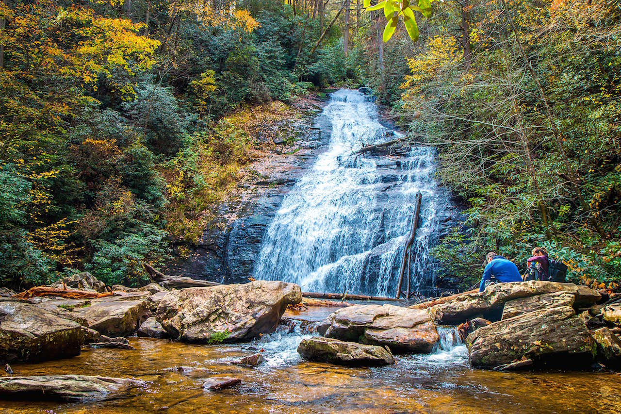
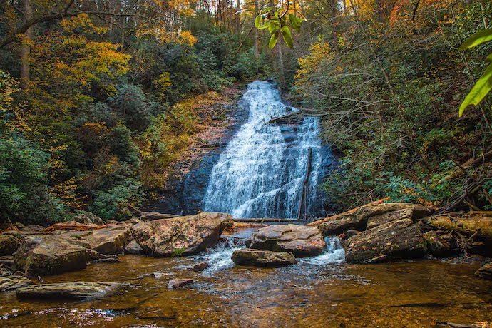
Long Creek Falls
Suches, GA
Distance from Blue Ridge: 24.6 miles (46 min drive)
Level of difficulty: Easy
Trail Length: 1.9 miles
Elevation Gain: 301 feet
Of the five waterfalls in Fannin County, Long Creek Falls is arguably the most popular.
This is largely because of the beautiful 50-foot waterfall itself. But also because of its location on the Appalachian Trail near Three Forks, where the AT, Benton MacKaye, and Duncan Ridge Trails come together.
The hike to the falls is enjoyable in its own right. The trail meanders beside Long Creek, leading you through a lush forest filled with rhododendron, hemlock, and tulip poplar.
When you reach the falls, you’ll be treated to a gorgeous display of water surging down 50 feet before collecting in a serene creek surrounded by moss-covered boulders and stones.
Between the falls, creek, and surrounding flora, it’s definitely one of the most scenic spots for an afternoon picnic!
READ MORE: The 10 Best Wineries in the North Georgia Mountains
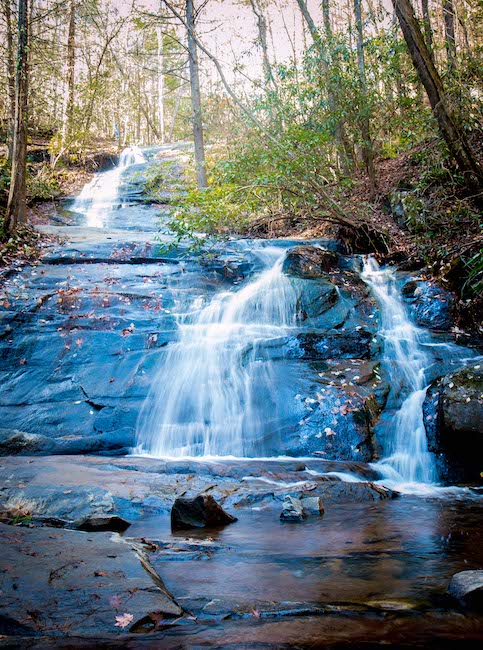
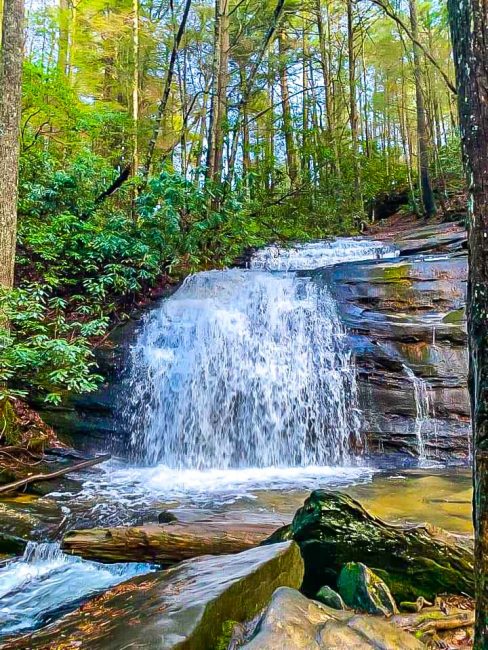
Sea Creek Falls
Suches, GA
Distance from Blue Ridge: 25.6 miles
Level of difficulty: Easy
Trail Length: 0.5 miles
Elevation Gain: 32 feet
Tucked away in the Coopers Creek Recreation Area (part of the Chattahoochee National Forest), Sea Creek Falls is a mesmerizing 30-foot waterfall that spills into a shallow pool.
The half-mile, in-and-out Sea Creek Falls trail follows along its namesake creek. It’s one of the easier waterfall hikes in GA, although it can become quite muddy after heavy rains.
The shallow, rock-filled pool at the base of the falls is great for splashing around in. It also provides a scenic spot to relax and enjoy the peacefulness that comes with being immersed in nature.
While the waterfall is beautiful at any time of year, it is particularly remarkable in late Winter or Spring, when the water flow tends to be stronger.
READ MORE: Lake Blue Ridge Boat Rentals, Cabin Rentals, Camping & Fishing
Helton Creek Falls
Blairsville, GA
Distance from Blue Ridge: 36.3 miles
Level of difficulty: Easy
Trail Length: 0.6 miles
Elevation Gain: 29 feet
Perfect for small kids and dogs, the Helton Creek Falls Trail is incredibly well maintained and is one of the easiest waterfall hikes in GA .
As you descend the trail’s entry staircase, you’ll immediately get a glimpse of the waterfall through the beautiful valley of hemlocks and hardwoods mixed with conifers and rhododendrons.
Soon after that you’ll reach a short side trail with a set of wooden stairs that guide you to the base of Helton Creek’s lower falls. Here, water rushes over a smooth rock face into a peaceful pool surrounded by ferns and verdant mosses.
If you continue on the main trail, there’s a short climb in elevation before you reach the Upper Helton Creek Falls viewing platform.
It showcases the taller and wider falls as they tumble over a massive rock outcrop, with lots of large boulders around that make this the perfect place for an afternoon picnic.
READ MORE: The 10 Best Restaurants in Blairsville GA for Foodies
DeSoto Falls
Suches, GA
Distance from Blue Ridge: 39.5 miles
Level of difficulty: Easy
Trail Length: 2.2 miles
Elevation Gain: 160 feet
Desoto Falls are a magnificent pair of North Georgia waterfalls where, legend has it, a piece of Spanish explorer Hernando de Soto’s armor was found from his North American expedition in the mid-1500s.
The hike is fairly easy, with minimal elevation gain. And, at just over 2 miles, the kid-friendly distance makes this waterfall very popular with families.
From the paid parking area, you’ll follow a paved path before crossing a wooden bridge over the rhododendron-lined banks of Frogtown Creek. Here, you’ll get your first sight of the lower DeSoto Falls.
At around 1/4 of a mile, you’ll reach a wooden viewing platform that allows you to see the lower falls up close. But the truly breathtaking sights come after crossing another wooden bridge, where you’ll reach the gorgeous cascades of upper Desoto Falls.
There’s a spacious viewing platform here where you can stop for a picnic, rest, and take in the beauty of the nearly 80-foot falls.
READ MORE:The 10 Best Kayaking Rivers in Georgia
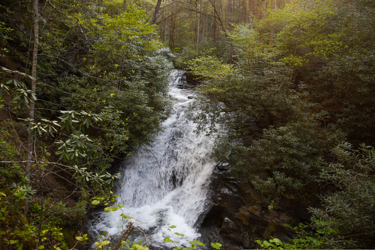
Raven Cliffs Falls
Helen, GA
Distance from Blue Ridge: 42.6 miles
Level of difficulty: Moderate
Trail Length: 4.9 miles
Elevation Gain: 400 feet
Surrounded by towering hardwood trees, verdant moss, and creek banks lined with vibrant wildflowers, Raven Cliffs Falls is easily one of the most beautiful waterfalls in northern Georgia.
The Raven Cliffs Falls trail follows the tranquil Dodd Creek upstream before crossing a wooden bridge and continuing through the forest, where you’ll spot a number of meandering streams and smaller cascades along the way.
Before you see even the falls, the sound of the rushing water will fill your ears.
At just over 2 miles, you’ll come face-to-face with the striking 40-foot tall falls, where the water plummets down a massive rock outcrop before settling into the pool below.
This is one of those spots that are hard to pull yourself away from. But when you’re ready to complete the hike, just follow Dodd Creek back downstream to the trailhead.
READ MORE:The 10 Best Places for River Tubing in North Georgia

Dukes Creek Falls
Helen, GA
Distance from Blue Ridge: 43.5 miles
Level of difficulty: Easy
Trail Length: 2 miles
Elevation Gain: 300 feet
Nestled in the heart of North Georgia’s Blue Ridge region, the hike to Dukes Creek Falls is an extremely kid- and dog-friendly adventure that is also partially wheelchair-accessible.
Starting from a parking lot that offers a great view of Yonah Mountain, the beginning of the trail is paved and leads to an ADA-accessible viewing platform, where you can get a first look at the falls.
The trail will then turn to dirt and begin to drop in elevation as you make your way down, with occasional sightings of Dukes Creek along the way.
One unique thing about this hike is that the upper part of the waterfall is fairly visible throughout. You’ll also be treated to several sightings of smaller cascades along the way to motivate you to keep going.
Of course, the best views come when you reach the observation platforms at the base of the falls, where you’ll be treated to exceptional views of the 150-foot cascades. –by Christina Maggitas
READ MORE: The Best Places to Go White Water Rafting in GA

