
[Updated April 3, 2022]
It’s not difficult to understand why Horse Trough Falls is one of the least visited waterfalls in Helen GA once you decide to explore the area for yourself.
The Horse Trough Falls trailhead is located at the back of the Upper Chattahoochee River Campground, which is tucked about 5 miles off the main road in the 16,400-acre Mark Trail Wilderness.
To get there, you’ll take a long, winding gravel road that’s riddled with massive potholes, and rarely wide enough to accommodate two vehicles at once. The ruggedness of this wilderness cannot be overstated.
Overgrown foliage, sizable rocks, and considerable ruts due to erosion along the old forest service road makes driving VERY slowly an absolute necessity. We did it in a Hyundai Elantra, but a 4WD vehicle is definitely recommended.
Once we reached the campgrounds’ parking lot, we quickly realized another reason why Horse Trough Falls is rarely traveled these days.
When we visited in 2021, the Upper Chattahoochee River Campgrounds had clearly been closed for quite some time. Hiking through it to reach the actual Horse Trough Falls trailhead was almost eerie, as if nature was gradually reclaiming the recreation area bit by bit.
Still, the unspoiled beauty you’ll see at the end of the short, easy walk makes this one of our favorite hiking trails in North Georgia. And now the campground has reopened, making it possible to camp there overnight!
Read on for our guide to hiking the Horse Trough Falls Trail, including driving directions, some history of the area, and an overview of the sights you’ll see along the way.
READ MORE: 101+ Things to Do in North Georgia
Horse Trough Falls Info
ADDRESS: Upper Chattahoochee River Campground, 48 Forest Service Road 44 (a.k.a. Chattahoochee River Rd), Helen GA 30545
PHONE: 706-754-6221
COST OF ENTRY: Free
WEBSITE: www.fs.usda.gov
HOURS: Open 24 hours a day. When the North Georgia campgrounds are open, quiet hours are 10pm-7am.
HIKING TRAIL: Normally rated as an easy, 0.4-mile round-trip, rarely trafficked hike. While the Upper Chattahoochee River Campground is closed, it’s approximately 1.4-miles round-trip.
AMENITIES: All of the campsites have a picnic table, grill, fire ring, lantern post, and fresh water access. There’s also a restroom in the campground.
Love North GA Waterfalls? Check out these great guides!
The 20 Best North Georgia Waterfalls (& How to Get to Them)
The 10 Best Waterfalls Near Helen GA
The 10 Best Waterfalls Near Blue Ridge GA
How to Get to Anna Ruby Falls Near Helen GA
How to Get to Dukes Creek Falls Near Helen GA
How to Get to Helton Creek Falls in Blairsville GA
How to Get to Hemlock Falls at Moccasin Creek State Park
How to Get to Minnehaha Falls on Lake Rabun
How to Get to Panther Falls & Angel Falls at Lake Rabun Beach
How to Get to Long Creek Falls in Blue Ridge GA
Horsetrough Mountain/Falls History
Horse Trough Falls is located in the heart of the Blue Ridge Mountains of North Georgia, which were formed when continental plates collided around 300 million years ago.
Most of the 749,689-acre Chattahoochee National Forest was once inhabited by the Muscogee/Creek and Cherokee people.
They were removed from their ancestral homes after the signing of the Treaty of New Echota in 1835, and forced to travel the Trail of Tears to reservations in Oklahoma.
By the late 1800s, the area around what is now the mountain town of Helen was being deforested at an alarming rate.
So the Chattahoochee National Forest was established in 1936 in order to restore the forest and protect both the watershed and the wildlife that inhabits it.
Horse Trough Falls is right at the heart of that watershed. The bridge to reach the North Georgia waterfall is the first one near the headwaters of the Chattahoochee River, which runs some 430 miles south into Florida’s Apalachicola Bay.
READ MORE: The 15 Best Things to Do in Helen GA
After the decline of the logging and gold industries, White County emerged as a budding tourist destination in the mid-1950s. This was 20 years after the Civilian Conservation Corps (CCC) built a camp along Smith Creek, and businessman Charlie Maloof convinced the state to build a new highway to Hiawassee.
Maloof eventually became mayor of Helen, and proposed building a new lodge north of the city. After damming Smith Creek to create Smith Lake (a.k.a. Unicoi Lake), Unicoi State Park was born in the mid-’60s.
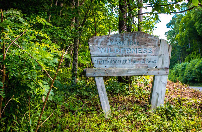
The 16,400-acre Mark Trail Wilderness, in which Horse Trough Falls is located, was designated by Congress in 1991. Managed by the US Forest Service, its highest point is the 4,045-foot Horsetrough Mountain, and 14 miles of the Appalachian Trail cross through the wilderness area.
Today, the unspoiled wildness of Horse Trough Falls feels a million miles away from the bustling town of Helen, which is widely considered one of the best places to live in the Georgia mountains.
READ MORE: The 15 Best Rental Cabins in Helen GA
Hiking the Horse Trough Falls Trail
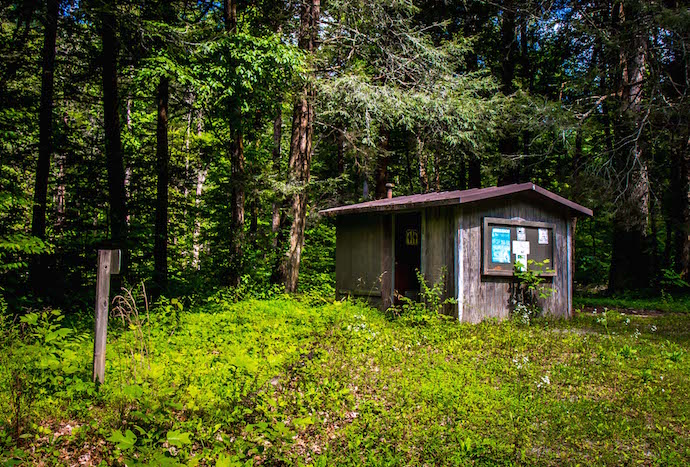
Since we didn’t know that the Upper Chattahoochee River Campground was closed, arriving at the campgrounds parking lot proved confusing.
There were no signs for the campground and no notice that it was closed. There was nothing but a large steel bar blocking the very entrance our map suggested we should take.
We walked around the gate and continued on foot, seeing a large Chattahoochee National Forest sign on the right hand side, which convinced us we were heading in the right direction.
Even in the light of day, walking through the seemingly abandoned 34-site campground proved somewhat haunting. According to the official US Forest Service site, it had been closed for more than 3.5 years due to tornado damage to Chattahoochee River Rd.
It looked it, too, with weeds and vines consuming picnic tables, climbing over lantern posts, and starting to cover the Helen campground’s lone restroom. But the mature forest all around it remains extraordinarily beautiful.
And now that the campground is reopened, it should be much easier to find your way.
READ MORE: 10 Fun, Festive Ways to Celebrate Christmas in Helen GA
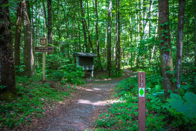
As you reach the end of the campground’s road, you’ll see the Horse Trough Falls Trail marker– a green diamond and the number 173– on the right side of the circular drive.
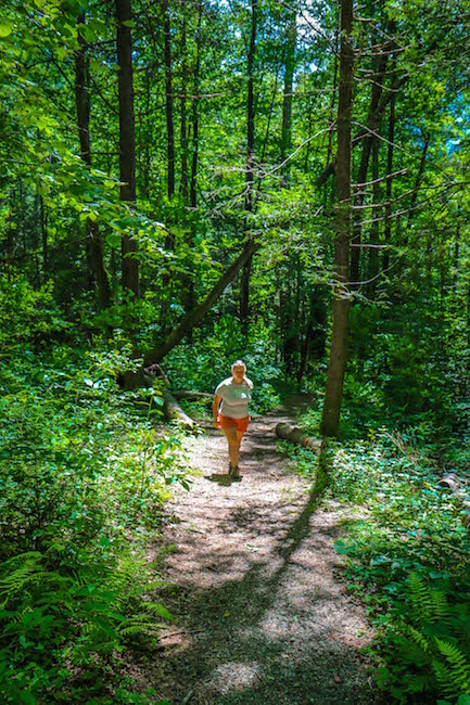
The easy trail seems well-maintained, with virtually no incline and loads of North GA wildflowers (including mountain laurel during our June visit) all along the path. The surrounding forest is so lush and verdant, we hope to revisit it when the area’s fall colors begin to peak.
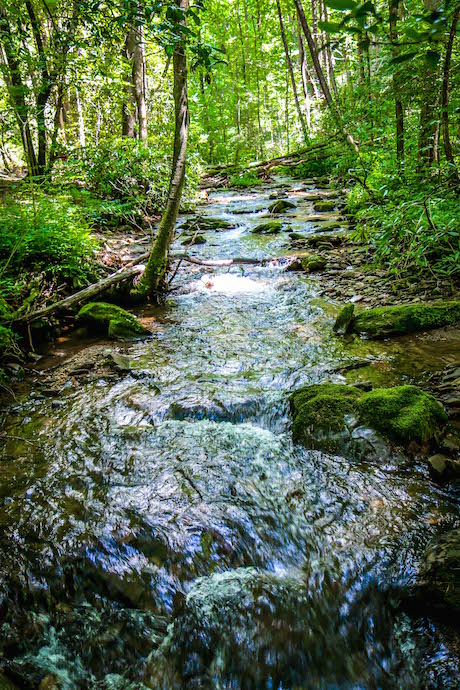
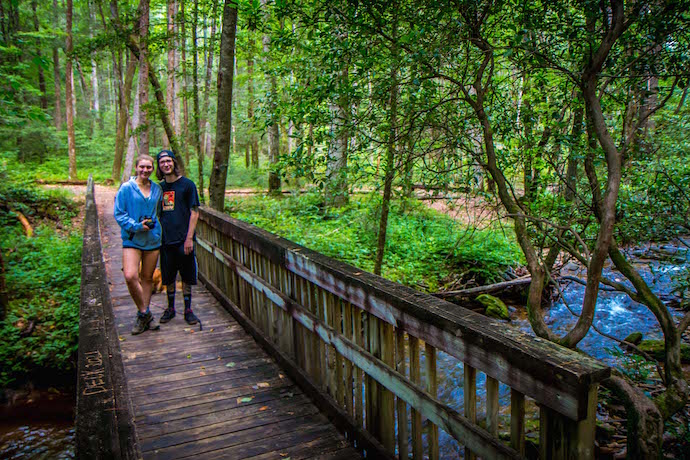
After the trail curves to the left, you’ll soon reach a bridge over the headwaters of the Chattahoochee River, which form less than a mile away in Chattahoochee Gap on Coon’s Den Ridge.
Once you cross the bridge, you have two choices, one of which we knew nothing about before our visit.
Turn right and you can make the short trek to Chute Falls, which is considerably smaller but worth the time and energy. Turn left and Horse Trough Falls will be within sight in a matter of minutes.
READ MORE: The 10 Best Restaurants in Helen GA for Breakfast, Lunch & Dinner
Viewing the Waterfall
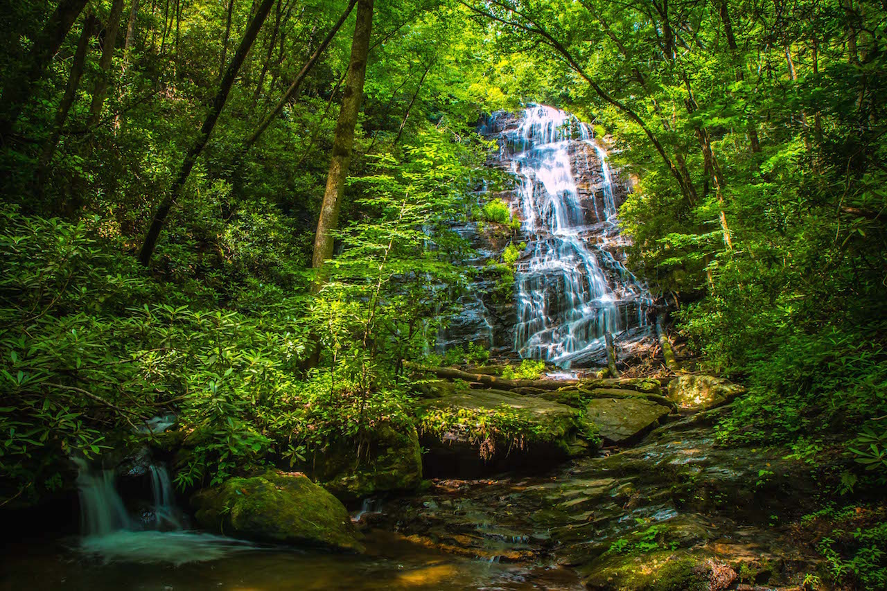
The trail ends at a wooden viewing platform, high in the Chattahoochee watershed, with one of the flanks of Horsetrough Mountain looming large above you.
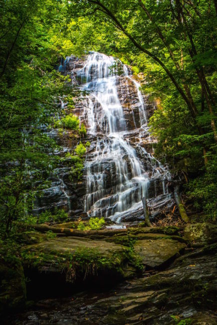
The 70-foot-tall waterfall spills dramatically over the side of the North Georgia mountain, cascading down a dynamic rock outcrop into the creek (which feeds into the Chattahoochee River).
From here, the verdant foliage partially obscures your view of this spectacular Georgia waterfall. But a footpath to the right of the platform leads you on a trail to the massive rocks at the bottom of the falls.
Note that the rocks here are very slippery. Please exercise caution, wear hiking shoes or water shoes with good traction, and watch for water snakes that may be sunning themselves on the rocks.
But once you reach the base of Horse Trough Falls, the view is truly stunning. The rock face reveals itself to be much broader than it appears from a distance, sending the water spraying in mesmerizing patterns.
We visited in the late morning hours on a weekday in summer, and there wasn’t another soul in sight. The sunlight set the forest aglow, with leaves like radiant gems creating a halo effect around the falls.
The serene setting and large boulders would make this an exceptional place for an afternoon picnic, with the sounds of Horse Trough Falls, the gurgling creek, and chittering birds of Georgia providing a serene soundtrack.
READ MORE: The 10 Best State Parks With Cabins In Georgia
Horsetrough Falls Directions
Directions to Horsetrough Falls From Helen GA
From downtown Helen, take GA75 North for 8 miles to Unicoi Gap, then make a left turn onto FS Road 44 (Wilkes Creek Rd). You’ll see the Mark Trail Wilderness sign at the entrance.
Follow that road for 4.5 miles to a sharp curve and take the right fork, where you’ll find the Upper Chattahoochee River Campground parking area.
Directions to Horsetrough Falls From Blairsville GA
From downtown Blairsville, take US-129 S/US-19 South for 2.1 miles, then make a left turn onto Town Creek School Rd.
Follow that road for 6.2 miles, where you’ll turn left onto State Rte 180. Take that for 10.1 miles, then turn right onto GA-17 S/GA-75 S.
