

From the Appalachian Trail and Bartram Trail to an endless array of State Parks, WMAs, and waterfalls scattered throughout the region, North Georgia is an amazing place for anyone who loves hiking.
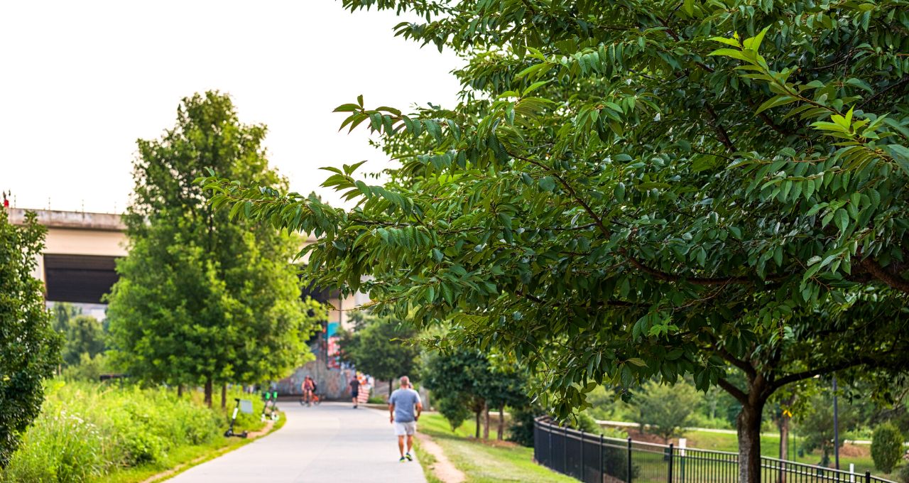
But even if you can’t make the drive to explore the Blue Ridge Mountains of North GA, hiking in Atlanta offers a surprising wealth of green space to explore.
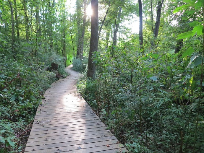
Popular hiking trails in Atlanta such as the Cascade Springs Nature Preserve and the Doll’s Head Trail at Constitution Lakes Park give you a chance to see native birds and wildlife in the heart of the city.
If you do have time to venture beyond the I-285 Perimeter, there are also some outstanding hikes near Atlanta, including hiking trails in Kennesaw, Roswell, Stone Mountain, Woodstock, and beyond.
All of these are technically part of the Atlanta Metropolitan Area, which is the 8th largest metro area in the United States.
Read on for our in-depth guide to the 20 best hikes in Atlanta GA, including the best access points, overall difficulty level, and the approximate round-trip distance of each trail.
READ MORE: The 30 Best Hiking Trails in North Georgia Bucket List
Best Hiking Trails in Atlanta GA Guide
- Atlanta BeltLine Eastside Trail
- Cascade Springs Nature Preserve
- Clyde Shepherd Nature Preserve
- Cochran Shoals Trail
- Doll’s Head Trail at Constitution Lakes Park
- East Palisades Trail
- Morningside Nature Preserve
- Powers Island Trail
- Arabia Mountain Top Trail
- Iron Hill Loop Trail at Redtop Mountain
- Kennesaw Mountain Trails
- Olde Rope Mill Park & Allatoona Falls
- Panola Mountain
- Pine Mountain Trails
- Sawnee Mountain Indian Seats Trail
- Silver Comet Trail
- Sope Creek Trail
- Stone Mountain Trail: Walk-Up & Cherokee Trails
- Sweetwater Creek State Park
- Vickery Creek Trail at Roswell Mill
READ MORE: The 25 Best North Georgia Waterfalls (& How to Get to Them)
Hiking Trails in Atlanta GA
1. The Atlanta BeltLine Eastside Trail
Location: Piedmont Park, 1320 Monroe Drive NE, Atlanta GA
Difficulty: Easy
Distance: 3 Miles
Funded by private and public donations, the 3-mile Atlanta BeltLine Eastside Trail is an ongoing project designed to increase and improve natural and community spaces throughout the city.
The BeltLine’s projected completion date isn’t until 2029, yet it’s already one of the most popular and best hikes in Atlanta, with Instagram-worthy nature pics all along the way.
Along with self-guided hikes, visitors can see live music, take free fitness classes, use sports facilities, and picnic in Perkerson Park, Gordon White Park, and other parks along the BeltLine.
The BeltLine’s Eastside Trailhead can be accessed at the intersection of 10th Street and Monroe Drive, in Piedmont Park.
The BeltLine is free to access and often offers walking and bike tours for visitors. Interactive and downloadable maps are available online.
READ MORE: The 52 Best Georgia Hiking Trails for the 52 Hikes Challenge
2. Cascade Springs Nature Preserve
Location: 2852 Cascade Road, Atlanta GA
Difficulty: Easy
Distance: 1.6 Miles
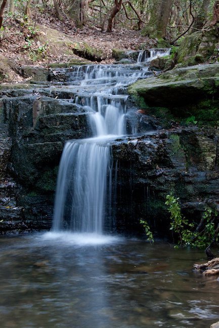
The 120-acre Cascade Springs Nature Preserve follows a creek surrounded by stunning historic structures, ultimately leading to the Cascade Springs waterfall.
The creekside hiking trail comes across an old stone springhouse, which kept the water clean from debris and kept meat and dairy products cool before fridges were invented.
This is one of the more popular Atlanta hiking trails due to the photogenic springhouse, which boasts a unique swirling design and has moss and ivy crawling up its sides.
After about 1.3 miles, you’ll reach Cascade Spring Falls, which rushes down the side of the steep slope and flows under an old bridge covered in crawling English Ivy.
Leashed dogs are allowed on the Cascade Springs trails, so feel free to bring your furry friends along!
READ MORE: The 25 Best Easy Hiking Trails to Waterfalls in Georgia

3. Clyde Shepherd Nature Preserve
Location: 2580 Pine Bluff Drive, Decatur GA
Difficulty: Easy
Distance: 1.5 Miles
The 28-acre Clyde Shepherd Nature Preserve is home to around 300 species of Georgia’s native flora and fauna, as well as numerous short hiking trails and a beaver pond.
The privately owned preserve’s goal is to protect wildlife habitats (including wetlands, ponds, and trees) in Decatur’s South Peachtree Creek Watershed.
The preserve occasionally offers guided nature hikes and community education programs focused on the conservation of wildlife in Georgia.
Trail maps are available to download onto any mobile device, showing hikers where they can can find benches, observation decks, bird feeders, and a photo blind.
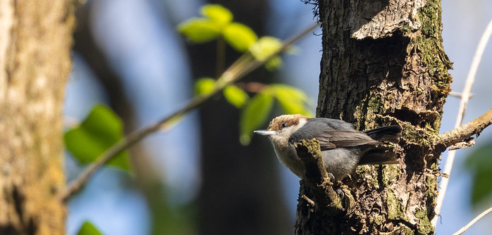
The Clyde Shepherd Nature Preserve is an especially great place for bird watchers: To date, around 165 species of birds have been recorded there.
READ MORE: 20 Beautiful Birds of Georgia
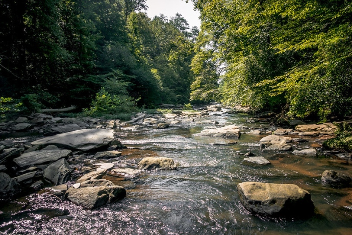
4. Cochran Shoals Trail
Location: 1956-2068 Eugene Gunby Road, Marietta GA
Difficulty: Easy
Distance: 3.1 Miles
The Cochran Shoals Trail is located in the Chattahoochee River National Recreation Area, which is one of the most popular places for hiking in Atlanta.
It’s widely considered among the best hiking trails near Atlanta due to its flat, wide path. So it’s suitable for trail running, family hikes, and taking side trails to explore the verdant forest.
With 3 miles of hiking trails along the Chattahoochee River, Cochran Shoals offers stunning views of the river, wetlands, and wildlife.
Weekends are a busy time to visit the Cochran Shoals Trail, so get there early (or go during the week) if you want to avoid the crowds.
READ MORE: The 10 Best National Parks in Georgia to Visit

5. The Doll’s Head Trail
Location: 1305 S. River Industrial Blvd SE, Atlanta GA
Difficulty: Easy
Distance: 1.6 Miles
Deep in Constitution Lakes Park lies a Atlanta trail that’s rich in artistic expression and local history. It’s also rich with Georgia snakes, so watch your step!
Accessed via the Rail Ridge Trail, the 1.6-mile Doll’s Head Trail was built by construction worker Joel Slaton in 2011, when he hit a rough patch after the 2008 recession.
This area was home to the South River Brick Company from the late 1800s to 1907, and it became a dumping ground for bricks, red clay, and trash from nearby homesteads.
Using junk he found discarded along the trail and in the old brick pits, Slaton built strange little structures in the trees and on the ground surrounding the path, which can be haunting for some visitors.
Note that hikers are encouraged NOT to add to the scary attraction, which prominently features dismembered doll heads and other discarded objects.
READ MORE: The 10 Most Haunted Places in Georgia to Visit
6. The East Palisades Trail
Location: 4058 Whitewater Creek Road NW, Atlanta GA
Difficulty: Moderate
Distance: 4 Miles
This Atlanta hike follows along the Eastern Banks of the Chattahoochee River, which offers opportunities for kayaking, river tubing, and white water rafting on Class I and II rapids.
The East Palisades Trail passes through one of Georgia’s few bamboo forests, stone walls of historic ruins, and high-elevation scenic overlooks.
The East Palisades Trail is pet-friendly (as long as they’re leashed) and offers four miles of well-marked paths for you to explore together.
If you’re craving more adventure after your hike, you can also visit the West Palisades Trail for a brand-new view on the opposite side of the Chattahoochee River.
READ MORE: The 10 Best Kayaking Rivers in Georgia
7. Morningside Nature Preserve
Location: 2020 Lenox Road NE, Atlanta GA
Difficulty: Easy
Distance: 2 Miles
Located in an upscale neighborhood in the Atlanta suburbs, the Morningside Nature Preserve protects land that was nearly razed to the ground and used for urban development in the late 1990s.
Thankfully, the preserve was funded by local residents in 2006 and has since been brought back to its relatively pristine natural state.
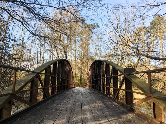
One of our favorite features of this trail is the wooden suspension bridge over South Fork Peachtree Creek, where you might see wildlife such as foxes, beavers, turtles, and birds.
Below the bridge is a sandy creek shore that is a popular beach for Morningside’s dogs to play.
Some of the preserve’s Eastern trails occasionally become overrun by plants, but most of the park’s hiking trails are easy enough for beginners.
READ MORE: 25 Fun Activities Where You Can Experience Fall in Georgia
8. Powers Island Loop Trail
Location: 5450 Interstate North Pkwy, Sandy Springs GA
Difficulty: Moderate
Distance: 2.6 Miles
This popular Atlanta trail was named after ferry operator James Powers, who provided rides across the Chattahoochee River during the 1800s.
The 2.6-mile is perfect for hikers who want to get away from the hustle and bustle of the city life, as well as nature photographers and wildlife lovers.
The Powers Island Loop Trail is rated as moderate due to the rock- and root-strewn path, but most able-bodied visitors are able to navigate it safely by paying attention to where they place their feet.
Like the East Palisades Trail, the Powers Island Trail crosses through the Chattahoochee’s evergreen bamboo forest, which is beautiful even after the fall colors in Georgia have faded.
READ MORE: The Best Christmas Lights in Atlanta and North Georgia
Hikes Near Atlanta GA
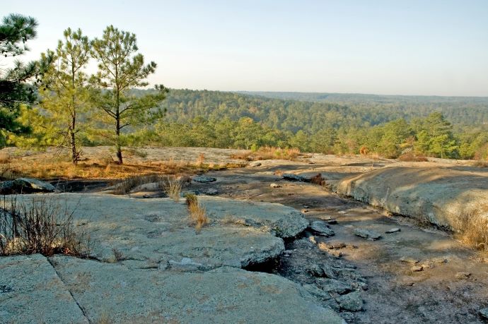
9. Arabia Mountain Top Trail
Location: Arabia Mountain, Stonecrest GA
Difficulty: Moderate
Distance: 1.3 Miles
Located in the Arabia Mountain National Heritage Area, this hike near Atlanta offers a unique landscape consisting of granite outcroppings and reflective pools.
Open from sunrise to sunset, the 1.3-mile Mountain Top Trail gets steep in some areas. So be sure to bring your hiking essentials, even though it’s considered to be a moderate hike.
At an elevation of 955 feet, the summit offers a reward for hikers once they reach the top of the trail– a stunning 360º view of the Georgia mountains (including Panola Mountain and Stone Mountain).
If you’ve been itching to see a bird’s-eye-view of the East Atlanta landscape, the Arabia Mountain Top Trail will give you the perfect scratch!
READ MORE: The 20 Best Hiking Trails in the Chattahoochee National Forest

10. Iron Hill Loop Trail
Location: Red Top Mountain Rd SE, Acworth GA
Difficulty: Moderate
Distance: 3.8 Miles
The 3.8-mile Iron Hill Loop Trail in Red Top Mountain State Park is set back from the State Park’s roads, exploring the shorelines and inlets of Lake Allatoona.
This trail is listed as moderate difficulty due to its gravel path, which crosses several wooden bridges.
Along with the Iron Hill Loop, Red Top Mountain offers 12.5 miles of hiking trails, as well as a full-service marina for boat rentals and jet ski rentals.
This is another dog-friendly trail, but hikers are urged to remain alert for passing mountain bikers so that you and your pooch don’t get injured.
READ MORE: The 20 Best Lakes in the North Georgia Mountains
11. Kennesaw Mountain Trails
Location: 900 Kennesaw Mtn. Drive, Kennesaw GA
Difficulty: Moderate
Distance: 20+ Mile Trail Network
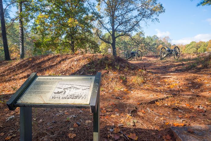
The Kennesaw Mountain trails are part of Kennesaw Mountain National Battlefield Park, the site of an important 1864 battle during the Atlanta Campaign of the Civil War.
This intermediate trail offers an opportunity to view one of the mostly important Civil War battlefields in Georgia, including some canons used in the historic battle.
The park also offers environmental trails and a battlefield trail, which are rated as moderate in difficulty and include steep terrain leading to the summit of Kennesaw Mountain.
Due to the rocky terrain, hikers should come prepared for a bit of a challenge. But on clear days the summit rewards you with views of Stone Mountain and the Downtown Atlanta skyline.
READ MORE: The 15 Best Historic Sites in Georgia

12. Olde Rope Mill Park & Allatoona Falls
Location: 690 Olde Rope Mill Park Rd, Woodstock GA
Difficulty: Easy
Distance: 3.2 Miles
With over 20 miles of mountain biking and hiking trails, Woodstock’s Olde Rope Mill Park is also a fantastic area for kayaking, fishing, or wading in the Little River.
The numerous trails include one that leads to the ruins of the Depression-era Rope Mill, which was destroyed in 1950 during the construction of Lake Allatoona.
There’s an unmarked trail in the park leads to Allatoona Falls (a.k.a. Toonigh Creek Falls), which can be reached by hiking on foot or via paddling a kayak or canoe from the lake.
Olde Rope Mill Park also features designated picnic areas, a covered pavilion, and numerous swings and benches for those who want to relax and enjoy its natural beauty.
READ MORE: The 24 Best Pumpkin Patches in Georgia to Visit
13. Panola Mountain
Location: 2620 Highway 155 SW, Stockbridge GA
Difficulty: Moderate
Distance: 30+ Mile Trail Network
Designated as a National Natural Landmark in 1980, Panola Mountain State Park is protected by the State of Georgia as a place of notable biological and geographical features.
Within the State Park, you’ll find the 15-acre Alexander Lake as well as distinctive granite formations similar to those of nearby Stone Mountain and Arabia Mountain.
Because of the trail’s moderate difficulty and the area’s delicate biology, Panola Mountain visitors need to make reservations in order to climb to the mountain’s summit with a park ranger.
But visitors to the state park do not need a reservation to hike the 1.3-mile Alexander Lake Loop Trail, which features rocky outcroppings and beautiful pine forest.
READ MORE: The 25 Best Day Trips From Atlanta GA
14. Pine Mountain Trail
Location: 2970 Georgia 190, Pine Mountain GA
Difficulty: Moderate
Distance: 23 Miles
The Pine Mountain Trail network is in the 9,049-acre Franklin D. Roosevelt State Park, the largest of the North Georgia state parks.
This 23-mile trail (indicated by a Blue blaze) offers wondrous views of the Pine Mountain ridge valley and its scenic overlooks, wildlife, and waterfalls.
The trail starts at the park entrance off Highway 27 across from the Callaway Gardens Country Store and ends at the WJSP TV Tower on Highway 85W.
But there are also 6 shorter loop trails along the way, ranging from 3.2 to 7.8 miles, that make great day hikes for many of the 60,000 hikers who visit each year.
For those who want to do a multi-day trek, there are 16 designated backcountry campsites available for reservation at FDR State Park, but you must have a permit.
READ MORE: The 15 Best Campgrounds in North Georgia
15. Sawnee Mountain Indian Seats Trail
Location: 2500 Bettis Tribble Gap Road, Cumming GA
Difficulty: Moderate
Distance: 4 Miles
If you’re a sunset enthusiast, the moderate Indian Seats Trail at Sawnee Mountain Preserve is truly a must-see. Much like Arabia Mountain and Stone Mountain, it features striking granite outcroppings.
The Sawnee Mountain area was previously home to the Cherokee, Creek, and prehistoric Native American tribes, and is thought to have been used for sacred ceremonies and rituals.
With interpretive signs guiding visitors through the area’s history (including abandoned Georgia gold mines), the trail offers an informative and educational experience.
If you’re visiting the preserve with kids, make sure you cut through the Yucca Trail, where you’ll happen upon a charming fairy garden and a treehouse!
READ MORE: Fall in the Mountains of North Georgia: 25 Places to See Fall Colors
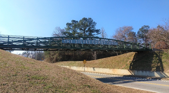
16. Silver Comet Trail
Location: Silver Comet Trail, Smyrna GA
Difficulty: Easy
Distance: 61.5 Miles
Built on abandoned railroad lines, the Silver Comet Trail runs 60+ miles, from Smyrna GA west to the Alabama border (where it becomes the Chief Ladiga Trail).
The 12-foot wide rail trail is paved and relatively flat, making it great for biking, hiking, or jogging.
Construction of this North Atlanta trail is ongoing. It will eventually link to the Atlanta BeltLine and Chattahoochee River trails, creating a city-wide network of Atlanta trails and recreation areas.
There are interactive online maps available for visitors, showing trail directions through three Georgia counties (Cobb, Paulding, and Polk) as well as popular tourist spots and hotels along the way.
READ MORE: The 15 Best Fall Fairs in Georgia to Visit
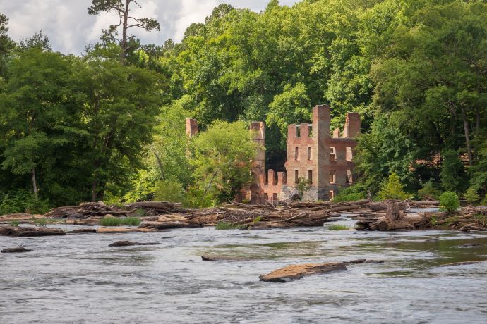
17. Sope Creek Trail
Location: 3726 Paper Mill Road SE, Marietta GA
Difficulty: Moderate
Distance: 1.5 Miles
Part of the Chattahoochee River National Recreation Area, Marietta’s Sope Creek Trail is home to the castle-like ruins of a paper mill that was destroyed and abandoned during the Civil War.
The 1.5-mile creekside trail is a loop, so you’ll get to see both the haunting paper mill ruins as well as Sibley Lake (in which fishing is allowed) along the way.
The Sope Creek Trail connects to the aforementioned Cochran Shoals Trail via a walkway, so hardy hikers could easily combine these two Atlanta trails for a moderately difficult 4.6-mile trek.
There are also several mountain biking trails nearby, plus water-based activities such as fishing and kayaking. So the recreation area is a great place for a full day of outdoor adventure!
READ MORE: The 15 Best Breweries in Georgia

18. Stone Mountain Hiking Trails: Walk-Up & Cherokee Trails
Location: 1000 Robert E. Lee Blvd, Stone Mountain GA
Difficulty: Moderate & Challenging
Distance: 15-Mile Trail Network
Open daily from dawn to dusk, the Walk-Up Trail at Stone Mountain Park is a moderately difficult trek that takes hikers 1,686 feet up to the top of the iconic mountain.
Yellow arrows and trail-markers make it easy to follow the path to the summit, where you can see spectacular 360º views that, on clear days, stretch for 60 miles.
The Cherokee Trail (marked with red arrows) lies at the base of Stone Mountain. It was designated as a National Recreation Trail in 1971 due to its representation of the area’s geography and indigenous people.
Since most visitors take the Walk-Up Trail, the Cherokee Trail is arguably the most peaceful hiking trail near Atlanta. It offers lots of sunny patches and stunning views of the stark granite rock formations.
If you do choose to climb Stone Mountain, it’s important to remain mindful of your step, as these rocks get especially slippery after it rains.
READ MORE: 52 Best Georgia Hiking Trails for the 52 Hikes Challenge
19. Sweetwater Creek State Park
Location: 1750 Mount Vernon Rd, Lithia Springs GA
Difficulty: Easy
Distance: 20+ Mile Trail Network
Located in Lithia Springs GA, Sweetwater Creek State Park offers hiking trails near Atlanta that wind through the park’s azaleas, hardwood forest, ferns, and wildflowers.
Like Kennesaw Mountain and Sope Creek, the State Park has a trail that leads hikers by Civil War-era ruins, these from the New Manchester Manufacturing Company textile mill.
Park visitors need to make a reservation for a guided tour with a Park Ranger if they want to visit the mill.
Sweetwater Creek State Park also has plenty of other amenities, in case hikers want to make a day trip out of their visit to the park.
The 200+ acre George Sparks Reservoir is great for fishing, and they have yurts, picnic shelters, campgrounds, and an event room available for rent.
READ MORE: The 25 Best Fall Fairs and Festivals in Georgia
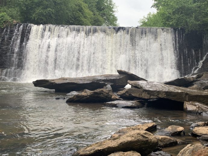
20. Vickery Creek Trail at Roswell Mill
Location: 1 Mill Street, Roswell GA
Difficulty: Moderate
Distance: 4.7 Miles
Although it’s part of the Chattahoochee River National Recreation Area, the Vickery Creek Trail at Roswell Mill doesn’t follow the banks of the river. But it does boast one of metro Atlanta’s best waterfalls!
The Roswell Mill (one of two mills situated along the trail) was home to the Roswell Manufacturing Company, and was destroyed during the Civil War‘s Atlanta campaign.
The ruins lie alongside the Vickery Creek Trail, and the wide waterfall was created by a dam that was built to provide water and power to Roswell’s mills.
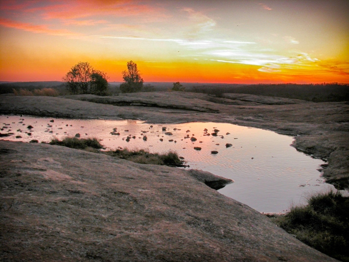
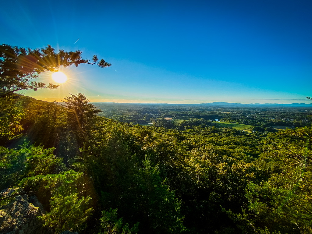
For help navigating the 4.7-mile Vickery Creek Trail to the falls and mill ruins, trail maps are available on site and online. –by Kait Miller; featured image of Stone Mountain Sunset courtesy Chenyi Pao


