
Reaching the picturesque summit of the Blood Mountain trail felt very much like conquering a mountain, both literally and metaphorically.
The strenuous uphill climb continues to get more challenging as you make your way to the top, with the promise of a spectacular Blue Ridge Mountains view like the dangling carrot-on-a-stick to keep you going.
Although I was suitably wowed by the dynamic scenery once I crested the peak, my biggest take away from the trek actually came from the other hikers I passed as they were descending the mountain.
Hiking Blood Mountain is one of the most popular things to do in North Georgia. And, as someone who generally seeks serenity and solitude in the woods, it would’ve been easy for me to feel rattled by the sheer number of hikers I saw on the trail.
However, each one of them, without fail, encouraged me as they passed. “It’s worth it, keep going!” they said. “You’re almost there!” “I see you have your camera out already– you’re going to love it up there!”
That positive energy of encouragement is an infectious thing. Instead of seeing other hikers as a distraction, I began to see the beauty of our collective journey, to overcome the obstacles that lie between us and our goals.
Read on for a detailed guide to hiking the Blood Mountain trail, including some history of the area, a description of the 4.3-mile round-trip hike, and driving directions.
READ MORE: The 15 Best Things to Do in Blairsville GA & Union County

Blood Mountain Info
ADDRESS: Byron Reece Trailhead, Blairsville GA 30512
PHONE: 706-745-6928
COST OF ENTRY: Free
WEBSITE: www.fs.usda.gov
HIKING TRAIL: 4.3 miles round-trip, rated Strenuous
AMENITIES: None
Love Hiking North Georgia? Check out these great guides!
How to Get to Anna Ruby Falls Near Helen GA
How to Get to Helton Creek Falls in Blairsville GA
How to Get to Hemlock Falls at Moccasin Creek State Park
How to Get to Minnehaha Falls on Lake Rabun
How to Get to Panther Falls & Angel Falls at Lake Rabun Beach Campground

Blood Mountain History
The Blood Mountain Trailhead is located on the border of Lumpkin County and Union County, in the Chattahoochee National Forest.
Historians are divided on the origin of Blood Mountain’s name.
Some believe it came from a bloody battle between the Creek and Cherokee people, while others suggest it may have been named for the red lichen, Catawba Rhododendrons, and other North GA wildflowers that grow near the summit.
All of the area surrounding the mountain was originally inhabited by the Cherokee, who were forced to give up their land and head west on the Trail of Tears after the signing of the Treaty of New Echota in 1835.
The area’s growth boomed after the 1829 discovery of gold near Dahlonega GA, which set off the Georgia Gold Rush.
Lumpkin County (named after Georgia Governor Wilson Lumpkin) was officially established in 1832, when it was carved out of parts of Cherokee, Hall, and Habersham Counties.
Union County, which was also founded in 1832, experienced a similar population explosion after gold was discovered in Dukes Creek.
READ MORE: The 10 Best Restaurants in Blairsville GA for Foodies

In 1921, noted conservationist Benton Mackaye (who co-founded The Wilderness Society) proposed to create the Appalachian Trail, of which the 4,459-foot Blood Mountain is the highest peak in Georgia.
By 1925 he had enough support to organize the Appalachian Trail Conference, with the mission to present more specific plans to rally support in creating the world-renowned hiking trail.
The Blood Mountain shelter was built in the 1930s by the Civilian Conservation Corps, offering thru-hikers a place to rest before continuing on their 2,190-mile Appalachian Trail trek to Maine.
In 1937, Judge Arthur Perkins, who ran the Appalachian Mountain Club, took over the reins of the ATC in order to speed up progress.
Thanks to the efforts of federal admiralty lawyer Myron H. Avery, construction of the epic trail along the eastern seaboard began soon thereafter. By the summer of 1937, the Appalachian Trail from Maine to Georgia was completed.
In 1968– 47 years after Mackaye first proposed the concept– the National Trails System Act was passed, making the Appalachian Trail the first National Scenic Trail in the USA.
READ MORE: The 15 Best North Georgia Mountains for Hiking

Hiking the Blood Mountain Trail
There are a couple of different ways to access the mountain, but all of them end up merging with the Appalachian Trail. The most commonly used Blood Mountain trail begins at the Byron Reece Trailhead near Neels Gap.
The mossy creek-lined path and stone stairs you’ll find in the forest on the Byron Reece Trail offer a beautiful and challenging start to this 2.1-mile ascent, which climbs some 1400 feet in elevation along the way.
At about the 0.8-mile mark, the trees begin to open up, offering you your first glimpse at the spectacular view that is waiting for you once you reach the summit.
This is when the hike turns right at a signed trail intersection, where you’ll see the Appalachian Trail cutting through. Here you’ll join the hardy thru-hikers making their way to the summit of Blood Mountain.
As you make your way up the increasingly strenuous Blood Mountain trail, you’ll alternate between hiking beautiful fern-lined paths, scrambling over boulders, and climbing what feels a bit like a rock ladder.
READ MORE: The 20 Best Hiking Trails in North Georgia Bucket List

At around the 2-mile mark, you can tell you’re reaching the top as you begin to climb over grooved rock slabs covered in lush lichen and moss.
You’re clearly in high elevation forest now, with hardwood trees, mountain laurel, rhododendrons, and other wildflowers all around you.
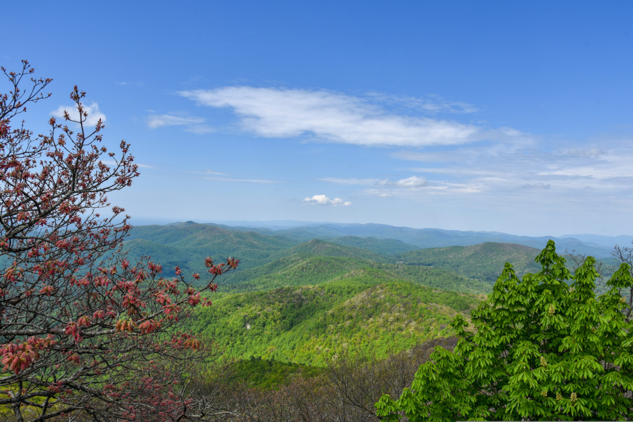
If the feeling of climbing 1,400 feet doesn’t leave you breathless, the staggering summit views (which look like the most hyper-realistic Bob Ross painting ever) will.
These are the sort of jaw-dropping views you can only see when you reach 4,459 feet of elevation, making Blood Mountain the Appalachian Trail’s highest elevation in Georgia, and the state’s 6th highest summit.
READ MORE: The 15 Best North Georgia State Parks & Historic Sites

The View Atop Blood Mountain
You’ll likely find yourself tempted to stop climbing once you reach the mountain’s first scenic vista, because it is simply so breathtaking.
But if you continue to hike along the mountain laurel-lined paths, you’ll find several other panoramic spots from which to take in different perspectives of Blood Mountain’s otherworldly views.
From the top of this massive rock slab, you can see the peaks of Mount Yonah, Tray Mountain, Lake Winfield Scott, and Slaughter Mountain.
Climbing up the massive boulders next to the Blood Mountain shelter offers another stunning view made even more potent by knowing you’ve shared it with thousands of AT thru-hikers who have walked this trail before you.
As I reached the top of the mountain, I found myself truly overwhelmed by the expansive vistas before me (not to mention the realization that I had completed one of the most challenging solo hikes I’ve ever attempted).
But the warm, welcoming people I met there were equally noteworthy, as we all gasped and exchanged comments on how beautiful everything was.
I listened as a family marveled at the different green shades of the fresh spring growth on the trees, and a teenager commented on how one tree glowed like gold when the lighting hit it just right.
Their insights really helped me to absorb and appreciate the sensational beauty I was witnessing while sitting on top of this massive rock formation.
It was an incredible communal experience I won’t soon forget– one that only served to enhance my passion for exploring the natural beauty of the great outdoors.
READ MORE: Vogel State Park: Camping, Hiking & History in Blairsville GA

Blood Mountain Directions
Directions From Atlanta GA
Take I-85 North to GA-400, then continue on GA-400/Greenville for 6 miles until you reach US-19 North/Gainesville Hwy.
Take US-19 North/Gainesville Hwy for approximately 64 miles, noting that the road will change names numerous times along the way.
The Byron Reece Trailhead will be on your left.
Directions From Blue Ridge GA
From downtown Blue Ridge, take 76 E for 20 miles, then turn right onto the Blue Ridge Highway. Follow that for 0.1 miles, then turn left onto Blue Ridge St.
In 0.3 miles, take a right onto Hunt Martin St, then follow it for 0.3 miles and turn right onto Cleveland St.
Take Cleveland St for 0.4 miles, then continue on US-129 S/US-19 S for 11 miles.
The Byron Reece Trailhead will be on your right. –text & photos by Hope Cross
