
With all apologies to TLC, chasing waterfalls in the beautiful Blue Ridge Mountains is one of our favorite pastimes.
And while my native state of Georgia may not have as many waterfalls as Western NC, the ones we do have are truly a sight to see, and often surprisingly easy to access!
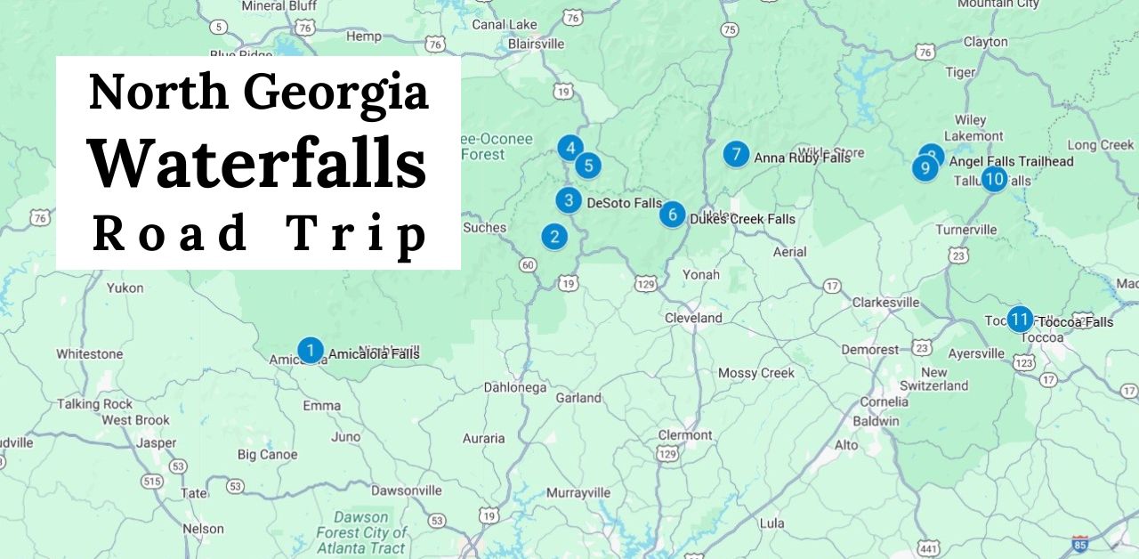
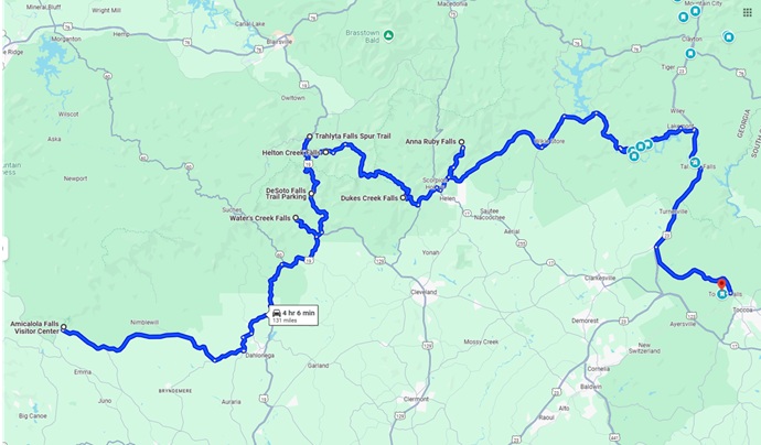
To that end, we decided to create our own North Georgia Waterfalls road trip, with 11 fantastic stops on a 131-mile route that can easily be broken up into a 3- to 5-day adventure.
Although there are other great waterfalls within 10-15 miles of this route (including popular spots like Raven Cliff Falls), we’ve chosen to limit it to easy and moderately difficult hikes, most of which are under 2 miles.
There are several great Blue Ridge Mountain towns worth visiting along the way, including personal favorites like Blairsville, Dahlonega, and Helen GA.
So, in addition to the map we created, we’ve also included suggestions for some of our favorite places to stay if you want to spend some time exploring the towns.
Read on for the ultimate Georgia waterfalls road trip, which includes more than 15 breathtaking beauties and less than a dozen total miles of hiking distance!
READ MORE: 101+ Things to Do in North Georgia
Places to stay near North Georgia Waterfalls
- Buck Moon Cabin 3.9mi to DT Blairsville 4br, hot tub, view, pet-friendly
- Comfort Inn .4mi to DT Blairsville, 2-star inn with pool and good breakfast
- 27 on Park Boutique Hotel downtown Dahlonega, 14 rooms, newly remodeled
- Quality Inn .6mi to DT Dahlonega, budget hotel near college, pet-friendly w/ breakfast
- Black Forest Bed & Breakfast .2mi from DT Helen w/ wonderful breakfast
- Riverbend Motel & Cabins .1mi from DT Helen on Chattahoochee River, pet-friendly, breakfast
- Mountain Aire Cottages & Inn – .8mi from DT Clayton, excellent location and quiet.
- White Birch Inn – 350 ft from DT Clayton, 5-star inn w/ fitness center, garden and a bar
Georgia Waterfalls Road Trip Guide
- Amicalola Falls (Dawsonville GA)
- Water’s Creek Falls (Cleveland GA)
- DeSoto Falls (Dahlonega GA)
- Trahlyta Falls (Blairsville GA)
- Helton Creek Falls (Blairsville GA)
- Dukes Creek Falls (Helen GA)
- Anna Ruby Falls (Helen GA)
- Angel Falls/Panther Falls (Lakemont GA)
- Minnehaha Falls (Lakemont GA)
- Tallulah Gorge State Park Waterfalls (Tallulah Falls GA)
- Toccoa Falls (Toccoa GA)
READ MORE: The 25 Best North Georgia Waterfalls (& How to Get to Them)
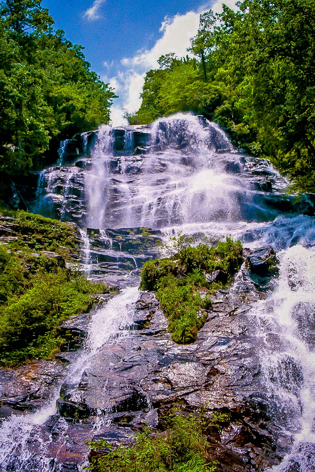
1. Amicalola Falls (Dawsonville GA)
Hiking Distance: O.3 miles • Difficulty: Moderate
We’ll begin our North Georgia waterfalls road trip at Amicalola Falls State Park, which is 8 miles from the southern terminus the Appalachian Trail and home to the tallest waterfall in the state.
Amicalola is the Cherokee word for “tumbling waters”– a great description of these 729-foot falls, which include 7 cascades.
Numerous hiking trails in the park offer views of the falls from different angles, including the wheelchair-accessible West Ridge Falls Access Trail and the one-mile East Ridge Trail.
The shortest trail is just 0.3 miles round-trip, but it’s rated moderately difficult due to the winding staircases you climb to a viewing platform right below the stunning falls. Trust us, it’s worth the effort!
READ MORE: The 15 Best North Georgia State Parks & Historic Sites
2. Water’s Creek Falls (Cleveland GA)
Hiking Distance: 50 yards • Difficulty: Easy • Distance From Amicalola: 35 miles
Leaving Amicalola Falls, you’ll take GA-52 E and US-19 N to this gorgeous gem.
It’s also known as Dick’s Creek Falls (which is confusing since there’s a waterfall by that name in Clayton GA), so we’re sticking with the official name here used by All Trails, Google Maps, and the US Forest Service.
Whatever you call it, it’s an awesome waterfall, with two noteworthy cascades within 50 yards of the parking lot.
Lots of locals come from Cleveland and Dahlonega in Summer to cool off in the swimming hole, so we recommend getting there early on weekends (or going on weekdays to avoid the crowd!
READ MORE: The 25 Best Easy Hiking Trails to Waterfalls in Georgia
3. DeSoto Falls (Dahlonega GA)
Hiking Distance: 2.2 miles • Difficulty: Easy • Distance From Water’s Creek: 7.6 miles
Located 17 miles from Downtown Dahlonega and 7.6 miles from Water’s Creek Falls, the DeSoto Falls Recreation Area boasts a beautiful 1.9-mile hiking trail that leads to a stunning pair of waterfalls.
It’s also believed to be where Spanish explorer Hernando de Soto’s armor was found from his expedition in the 1500s!
You’ll get your first sight of the rushing lower falls at a 1/4-mile, then hike a bit further and cross a wooden bridge to reach the magnificent cascades of Upper DeSoto Falls.
There’s a viewing platform where you can stop for a picnic, or just marvel at the nearly 80-foot-tall waterfall. But get there early if you go on a weekend, because it’s a VERY popular spot.
READ MORE: How to Get to the DeSoto Falls Scenic Area Near Helen GA
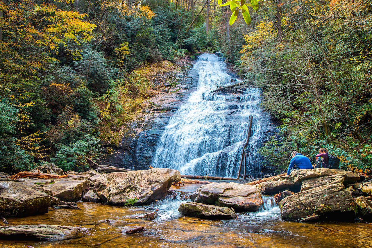
4. Trahlyta Falls (Blairsville GA)
Hiking Distance: 0.8 miles • Difficulty: Easy • Distance From DeSoto Falls: 6.6 miles
Located in one of North Georgia’s oldest state parks, just 6.6 miles north of DeSoto Falls (and 10 miles from Downtown Blairsville), Trahlyta Falls ranks among the most beautiful waterfall hikes in GA.
The short, easy trail starts near the Vogel State Park Visitors Center, and offers incredible views of Trahlyta Lake and Blood Mountain before making its way down the wooden stairs to the base of the cascades.
After descending the stairs, you’ll reach a spacious platform where you can get closeup views of the 110-foot-tall waterfall in all its glory.
Note that this spectacular waterfall can also be seen from a pull-off along Gainesville Hwy without even entering the park!
READ MORE: The 20 Best Hiking Trails in the Chattahoochee National Forest
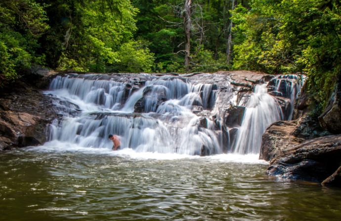
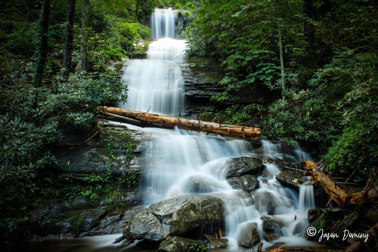
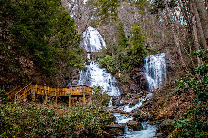
5. Helton Creek Falls (Blairsville GA)
Hiking Distance: 0.6 miles • Difficulty: Easy • Distance From Trahlyta Falls: 3.2 miles
Helton Creek Falls is 3.2 miles from Vogel State Park, and 7.5 miles from DeSoto. So you could stop to see Trahlyta Falls from the road, hike a total of 2.8 miles, and see nearly a half-dozen waterfalls in one glorious morning!
Like DeSoto, Helton Creek features two beautiful waterfalls. But the easy trail is just 0.3 miles each way, with less than 30 feet of total elevation gain.
The trail goes down a set of wooden stairs to the lower falls, where the water flows down into a crystalline pool of water perfect for wading and cooling off on a hot summer’s day.
When you’re done there, head to the viewing platform at the top, which offers the amazing view of upper Helton Creek Falls pictured above. It’s a great place for picnics, and there are lots of great Blairsville restaurants nearby.
READ MORE: How to Get to Helton Creek Falls in Blairsville GA
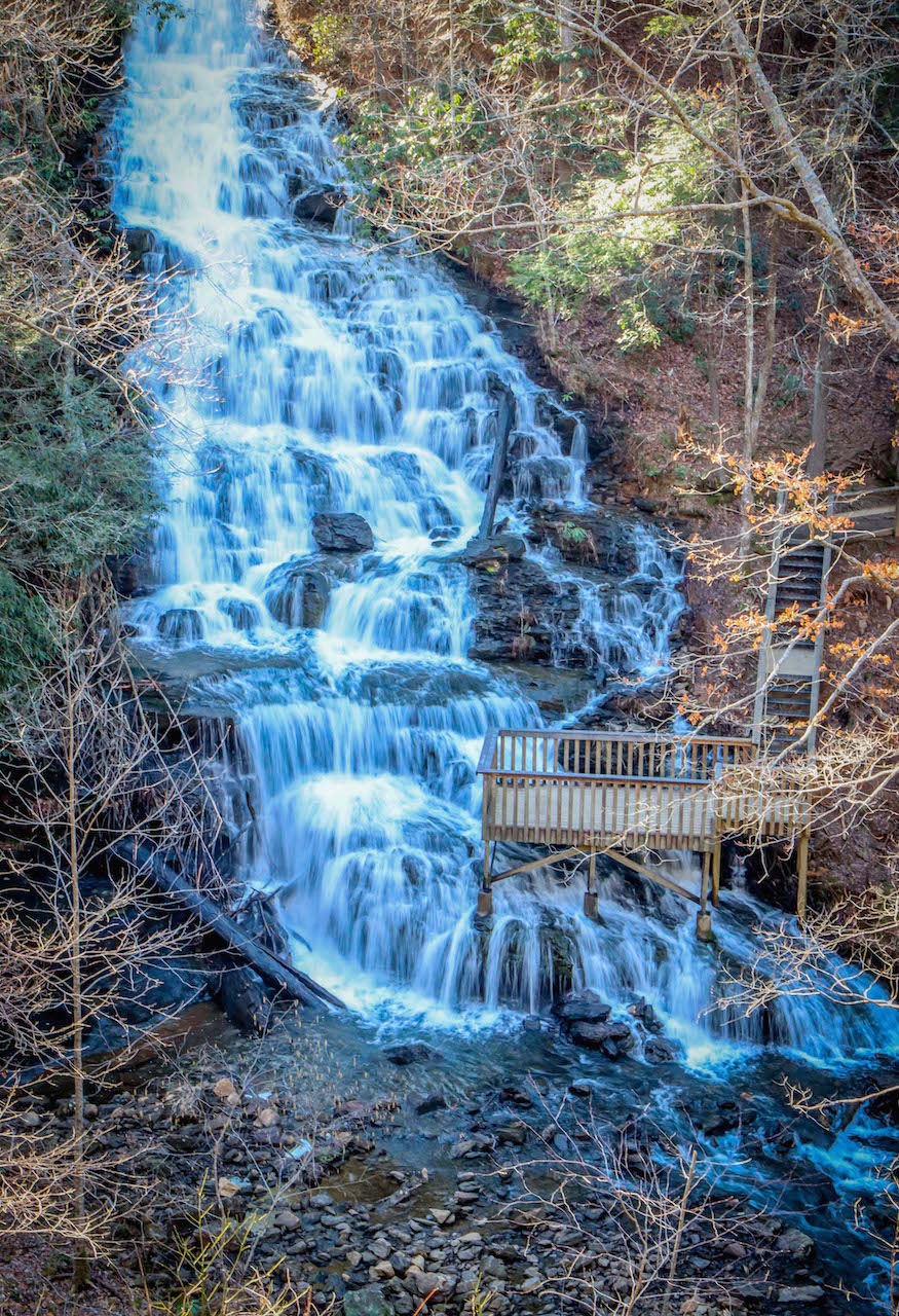
6. Dukes Creek Falls (Helen GA)
Hiking Distance: 2 miles • Difficulty: Moderate • Distance From Helton Creek: 7.6 miles
Making your way east towards the Alpine town of Helen GA, you’ll reach Dukes Creek Falls, one of the most popular waterfall hikes in Georgia. It was also a major attraction during the early 1800s Georgia Gold Rush.
Starting with an awesome view of Yonah Mountain, the paved trail leads to an ADA-accessible viewing platform at around 1/10th of a mile. There you can see the falls from a distance before descending stairs to the wide dirt path.
It’s a well-maintained trail, with several nice cascades along the way before you reach the large viewing platforms at the base of the falls. There’s also a popular swimming hole here, but it gets VERY crowded on hot summer days.
Note that the trail down to the falls is very easy, but the climb back up to the top is definitely a leg-burner.
READ MORE: How to Get to Dukes Creek Falls Near Helen GA
7. Anna Ruby Falls (Helen GA)
Hiking Distance: 0.8 miles • Difficulty: Moderate • Distance From Dukes Creek: 9.2 miles
One of our favorite waterfalls near Helen GA, Anna Ruby Falls is 5.7 miles north of the popular mountain town, right next to Unicoi State Park.
The Anna Ruby Falls trail is paved and short (0.4 miles each way), but is classified as moderately difficult due to the 219 feet of elevation gain.
If you want to take it slow, there are interpretive signs along the photogenic path detailing the area’s rich history, geology, and wildlife.
At the top you’ll find two wooden viewing platforms below twin waterfalls. There you can rest, have a picnic, and watch in awe as Curtis Creek drops 150+ feet and York Creek drops 50 feet before merging to form Smith Creek.
READ MORE: How to Get to Anna Ruby Falls Near Helen GA
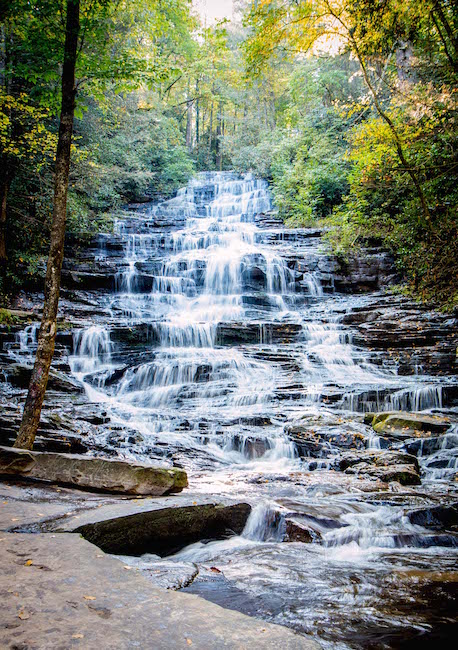
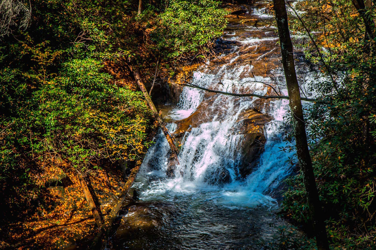
8. Minnehaha Falls (Lakemont GA)
Hiking Distance: 0.4 miles • Difficulty: Easy • Distance From Anna Ruby: 9.2 miles
Located 16 miles south of Clayton GA, Minnehaha Falls features a short, easy trail (just 62 feet of elevation gain) that arguably offers the best ROI of any waterfall in Georgia.
The hardest part is simply finding the trail, which is across the road from Lake Rabun. It’s easy to miss the Bear Gap trailhead, which is distinguished by a green diamond and the number 147.
You’ll climb a set of wooden stairs and walk a gentle incline through the forest for 0.2 miles, where the trees open up to reveal the multi-tiered cascades of Minnehaha Falls.
There’s a wide area at the base that’s scattered with rocks perfect for relaxing, having a picnic, and taking in the majestic sight of the 50-foot waterfall.
READ MORE: How to Get to Minnehaha Falls GA at Lake Rabun
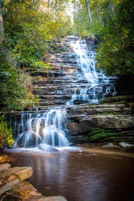
9. Panther Falls & Angel Falls (Lakemont GA)
Hiking Distance: 1.75 miles • Difficulty: Moderate • Distance From Minnehaha: 3.5 miles
The 1.75-mile trail to Panther Falls and Angel Falls starts on Loop 2 of the Lake Rabun Beach Campground (one of the most beautiful Campgrounds in North Georgia), following Joe Creek upstream.
From there you’ll ascend stone stairs and pass a stone bench built by the Civilian Conservation Corps in 1933.
At around 0.6 miles, you’ll reach Panther Falls, which is a great place to stop for a while and admire the picturesque waterfall, which tumbles down the rocks into a serene pool at the base.
Note that the elevation gain of the 1/3-mile hike up to Angel Falls is more strenuous, but it does have ropes for assistance. If you want an easier hike, you could simply retrace your steps from here.
READ MORE: How to Get to Panther Falls & Angel Falls GA

10. Tallulah Gorge State Park Waterfalls (Tallulah Falls GA)
Hiking Distance: Varies • Difficulty: Varies • Distance From Angel/Panther Falls: 9 miles
Formed over millions of years by the Tallulah River, the Tallulah Gorge is a 2-mile long, 1,000-foot deep chasm that’s home to several waterfalls and hiking trails of varying difficulties to reach them.
The 2-mile Hurricane Falls Trail is one of the most popular waterfall hikes in Georgia, exploring the north and south rims of Tallulah Gorge and featuring 10 scenic overlooks with jaw-dropping views.
There’s also the 3.4-mile Sliding Rock Trail, which gives you an up-close look at the Bridal Veil waterfall. For this hike, you’ll need to get a permit, which is free, but limited to just 100 per day.
For those with limited time or mobility, you can also view Hurricane Falls from the Rim Trail, which requires very little walking from the parking area.
READ MORE: The 20 Best Hiking Trails in North Georgia Bucket List
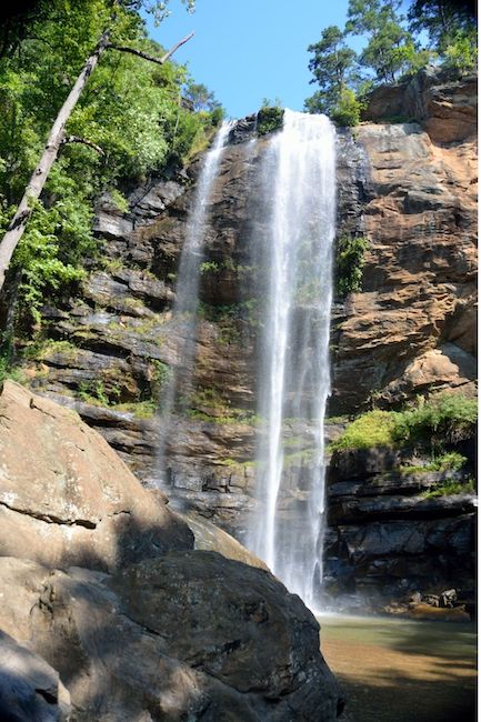
11. Toccoa Falls (Toccoa GA)
Hiking Distance: 100 yards • Difficulty: Easy • Distance From Tallulah Gorge: 17 miles
One of the tallest free-falling waterfalls in the eastern US, the 186-foot-tall Toccoa Falls is a breathtaking sight that requires ZERO hiking to see!
Located on the gorgeous grounds of Toccoa Falls College (about 300 feet from the visitor center/gift shop), this short, easy path is ADA-accessible.
It begins on asphalt and ends with gravel as you approach Toccoa Falls (which is nearly 20 feet taller than Niagara Falls), which drops into a steady stream that flows throughout the 1,000-acre campus.
It’s a lovely, gentle way to end your North Georgia waterfalls road trip! –by Bret Love & Christina Maggitas; all photos by Bret Love & Mary Gabbett unless otherwise noted
